About Us

Showing posts with label Mormon History Sites. Show all posts

Tuesday, July 26, 2016

Searching for Mormon Grove


I've felt very strongly that I need to teach my children the stories of their ancestors as a way to develop their character and resilience.  Look around- people are crazy out there!  You know what I mean!  I was on familysearch.org looking for stories to share with them, when I stumbled upon a great-whatever grandfather who died and was buried at Mormon Grove, Atchison, Kansas.  WOW!  This was crazy!  Atchison was only 20 miles from our home in Leavenworth.  I anxiously read the stories about John and Ann Bird and shared them with my family.  Then I set out to find where Mormon Grove was, in hopes that we could visit it.  I quickly learned that Mormon Grove is about 4-5 miles west of Atchison and that there is a historical marker on the side of the road, but outside of that, the actual site is on private property.
Interested in actually visiting the cemetery, we drove up to Atchison to look for the property owner.  After knocking on several doors in the area, many of the residents didn't know anything about a cemetery, but did know of the highway marker.  Finally though, an older lady told us to drive back to another road, follow it for a half mile, then knock on the door of the white farmhouse.  We did so, but nobody was home.
A month or so later, we were back in Atchison and decided to try again.  This time we were successful.  The man there managed the land for his father-in-law, who was the actual land owner, but gave us permission to go on it and look for the cemetery.  He said "I haven't been there, but go ahead and look.  You have more of a claim to it then I do."


We drove back to the marker, then west for a quarter mile, and parked at a red gate then walked in to look for where my however-many-great grandpa was buried. We didn't have a location, other then knowing it was there.  Interestingly enough, when the Kansas Highway Department was surveying for the highway, they learned about the cemetery, did some archeological surveys, then re-routed the highway to avoid going over the top of it.


We spent a delightful hour or two wandering the fields and hills looking for a cemetery.  We didn't find anywhere definitive that we could say "This is it", but just the same, the search was really fun, and it was unique to look at the same hills that my ancestors had 150 years before, knowing that John Bird was buried somewhere close by.  Although to the world this English emigrant lays unknown and forgotten, buried in an unmarked grave in the Flint Hills of Kansas, learning of him and his life has been an inspiration to me.

Nearest City: Atchison, KS
Location: N° W°
Time Needed:
Difficulty:
Kid Friendly:
Additional Info:

Thursday, November 26, 2015

Autumn visit to Nauvoo

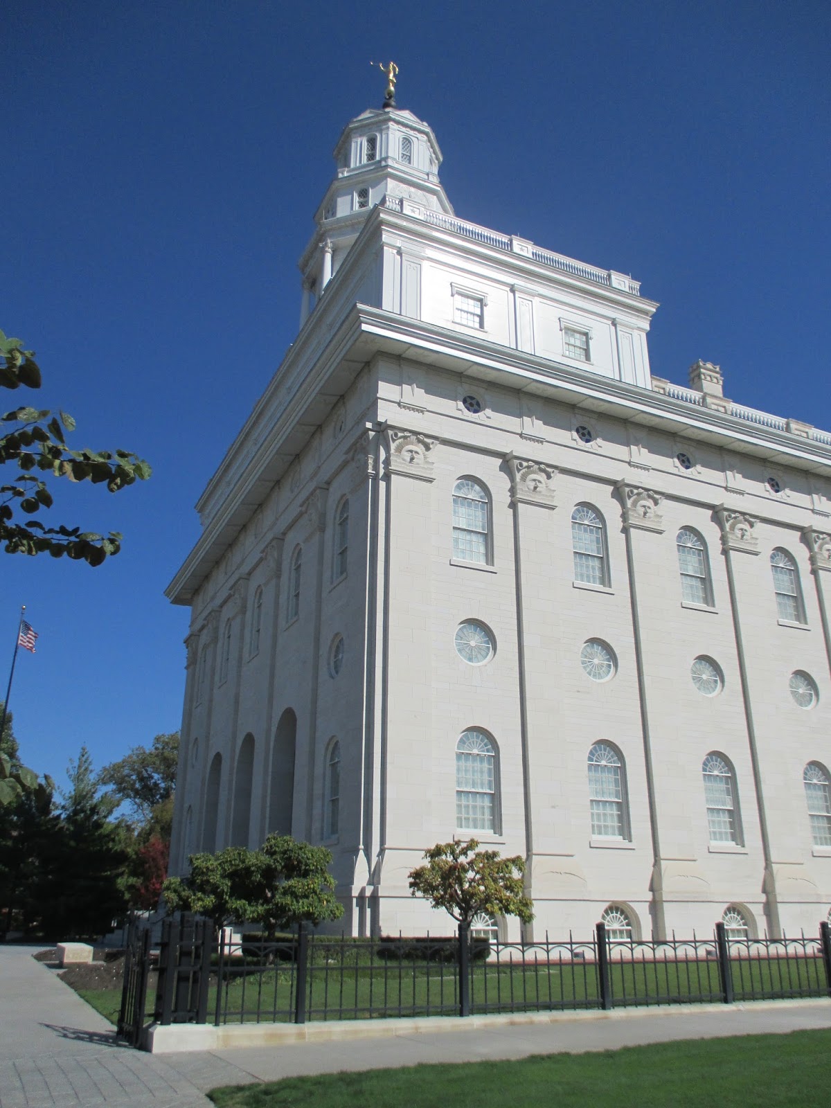
We had a good visit to Nauvoo this fall.  We made a point to visit several of the buildings that we didn't see on our January visit.  We visited the Lands and Records office and learned where some of our ancestors had lived here in Nauvoo.  We stopped by the Nauvoo Temple.  It was a beautiful trip and a great time to visit.  
One morning we drove up the road, I think it was Parley Street, from where we were camping in Nauvoo State Park to visit the Old Nauvoo Burial Ground.  
Across from Brigham Young's house there were several chestnut trees, and the missionaries gave us permission to pick some up and bring them home.  You could tell they were real chestnuts because the husk was prickly.  Poisonous false chestnuts do not have the prickly husk.
Another thing we really liked was the persimmon trees behind the Pendleton Schoolhouse.  The ripe and wrinkled persimmons were delicious!  I accidentally picked one that wasn't quite ripe, and it was anything but good.  We had a great time on our visit.  On Monday morning we picked up camp, toured two more houses, then headed home.

Nearest City: Nauvoo, IL
Location: N° W°
Time Needed: varies
Difficulty: easy
 Kid Friendly: yes
Additional Info:

Thursday, September 24, 2015

Winter Quarters Visitor Center and Pioneer Cemetery

While we were in Omaha, we also visited the Winter Quarters visitor center.  There's a lot of information at the center!  We learned all about pioneers crossing Iowa after they were forced by mob violence to leave Nauvoo, Illinios, preparations for their continued trek to Utah, and what made them unique when compared to other emigrant groups.  They were organized.  Rather then remain bunched together, they made about 200 settlements in the Winter Quarters vicinity to decrease their impact on the area.  They planted crops, established ferries, and did all they could to make it easier for the groups that followed them. The Mormon Trail Center gave a great overview into many facets of their lives, including transportation methods of wagon, handcart, ships, and railroads.
Across the street is the Winter Quarters pioneer cemetery and Winter Quarters Temple.  Most of the people buried in the cemetery were babies and children.  I have a relative buried there.  It's a place that encourages introspection and quiet reverence.  I am grateful for the sacrifices that were made by so many who have gone before.

Nearest City: Florence, NE
Location: 3215 State Street, Omaha, NE
Time Needed: 90 minutes
Difficulty: easy
Kid Friendly: yes
Additional Info:Mormon Trail Center Website

The Kanesville Tabernacle

While we were in Omaha, we drove across the river to Council Bluffs to visit the Kanesville Tabernacle.  The tour was pretty cool.  The original tabernacle was built in 1847 out of green cottonwood logs.  Because the logs were green, the walls warped and the building was demolished within a few years of being built.  In 1997, the replica was built on the site out of cottonwood logs by a historical society in Council Bluffs to celebrate the 150th anniversary of the Mormon's arrival in Utah.  It was then donated to the Church.
The tabernacle has a small Mormon Battalion exhibit, since Council Bluffs was where the Mormon  volunteers came from before reporting to Ft. Leavenworth to begin their epic march.

Two notable events happened at the Kanesville Tabernacle.  The first one was Brigham Young being sustained as 2nd Prophet and President of the Church of Jesus Christ of Latter-day Saints in December 1847.  It changed my perspective of Mormon history a little bit, since I had always assumed that Brother Brigham had led the Saints west to Utah, then stayed there in Salt Lake City, except for when he went to St George for the winter.  Nope.  He led them to Utah, then quickly turned around and went back to Iowa.

The second notable event was it was where Oliver Cowdry, one of the Three Witnesses of the Book of Mormon came to a church meeting after being separated from the church for a number of years and began the process of rejoining the church.

Nearest City: Council Bluffs, Iowa
Location: 222 E Broadway, Council Bluffs, IA
Time Needed: 45 minutes
Difficulty: easy
Kid Friendly: yes
Additional Info: Kanesville Tabernacle Website

Sunday, July 26, 2015

The Temple Site at Far West

We grouped Far West onto our trip to Adam-ondi-ahman, since they're about 30 miles away from each other.  Far West was definitely more crowded with visitors.  It used to be a Mormon community, but now it's a historic site on one side of the highway, and a white church on the other side.   In it's peak in 1838-9, just under 5,000 people lived in Far West.  For a time, The Church of Jesus Christ of Latter-Day Saints had its headquarters at Far West, but conflict led to the church relocating to Nauvoo, Illinois. 
The most interesting remainder at Far West is the Temple Lot.  The site was dedicated for a temple in 1838, and the cornerstones were laid, but the temple was never completed.  The four cornerstones are still in place.  There's also a stone monument etched with several revelations received by Joseph Smith at Far West: The name of the church, the restoration of the Law of Tithing, and a call to missionary work. 
While we were there, we noticed a tick crawling around on one of the kids' heads.  Watch out in Missouri for ticks!  They are there!  There are also a few Amish settlements in the area.  Yellow road signs will remind you to be courteous of the horses and buggies. 

Nearest City: Kingston, MO
Location: Intersection of Hwy D and 370
Time Needed: 20 minutes
Difficulty: easy
Kid Friendly: yes
Additional Info: Far West Historic Site

Weekend trip to Adam-ondi-ahman

In mid-May we took an overnight trip to Adam-ondi-ahman.  Friday after work, we drove up to the Holmes Bend Access near Gallatin, Missouri.  Missouri has a fantastic network of conservation areas, some of which have primitive camping areas.  We put this one to use, since it seemed to be the closest camping area to Adam-ondi-ahman.  As I was pitching our tent and getting camp set up, one of the kids found a night crawler.  He ran around excited about the big worm until it started crawling up his sleeve, at which point he panicked.  We carefully extracted the worm from his sleeve and he was more than willing to let it go crawl back with its family.  After I finished preparing our campsite, we walked over to a nearby marshy pond to look for frogs.  We saw a few but didn't catch any.  We then walked down the dirt road to look at the river access.  While we were walking back, there started to be small flashes of light in the bushes and undergrowth.  Fireflies!  It was finally warm enough for them to come out!  We watched the fireflies as they flickered in the darkening twilight then crawled in our tent to sleep. 
In the morning, we went to Adam-ondi-ahman, a Mormon history site  nearby. 
 It's a quiet mixture of fields and woodlands.  It's a spot where "Three years before he died, Adam called his righteous posterity into this valley and bestowed on them his last blessing (D&C 107:53–56). In 1838 Adam-ondi-Ahman was the location of a settlement of between 500 and 1,000 Latter-day Saints. The Saints abandoned this settlement when they were expelled from Missouri. Before Christ’s Second Coming in glory, Adam and his righteous posterity, which includes Saints of all dispensations, will again assemble in this valley to meet with the Savior (Dan. 7:9–10, 13–14; D&C 27; 107:53–57; 116)."
We went for a short walk and drove around the area as well.  There's really not much to see other than a few overlooks and a spot or two to get out and walk.

Nearest City: Jameson, MO
Location: Along Highway 13 between Jameson and Gallatin
Time Needed: 1 hour
Difficulty: easy
Kid Friendly:
Additional Info:

Saturday, July 25, 2015

The Independence Visitor Center, Temple Lot, and Community of Christ Temple

Independence Temple Lot portion owned by the Community of Christ (Temple Lot)
In May we went over to Independence to visit some church history sites and historic sites.  Our first stop was at the Independence LDS Visitor Center.  The visitor center was a good visit, with numerous exhibits on families, LDS church (Mormon) history in Missouri, and information on what Mormons believe.  Stop on in if you're interested!  Even if you're not interested in becoming a Mormon, I'm sure you could find things that are interesting.  In 1831, Mormon settlers moved to the Independence area and began to settle and build a community.  Within a year or two, many of the Mormons began to gather together in Independence.  Joseph Smith Jr, a modern day prophet, came and dedicated a lot in the town for a temple.  Friction with other settlers escalated and before a temple could be built, the Mormons were forced to move on.  First they moved north to Far West, Missouri, then shortly after that to Nauvoo, Illinois. 
The Temple of the Community of Christ
The temple lot has been subdivided into several pieces, which are now owned by different churches. The LDS Independence Visitor Center sits on a portion of the lot.  The Reorganized Church of Jesus Christ of Latter-day Saints, prior to becoming the Community of Christ, built their temple on one portion of the lot.  Another portion is currently vacant, but is owned by the Community of Christ (Temple Lot).  There was a detailed map I picked up at the LDS visitor center that showed the location of the temple lot, overlaid with current parcels and ownership. 

We stopped by the Community of Christ temple and quietly walked through it.  Its design was inspired by the conch shell.  The building functions as an administrative building, visitor center, museum, and temple.  Every day they have a Prayer for Peace at 1:00.  I found an interesting contrast between the Community of Christ Temple and those of The Church of Jesus Christ of Latter-day Saints.  If you have some time in Kansas City, stop by the Kansas City Missouri Temple and walk around the grounds.  I feel at peace there.

Nearest City: Independence, MO
Location: 937 W. Walnut Street, Independence, MO 64050
Time Needed: 1-3 hours
Difficulty: easy
Kid Friendly: yes
Additional Info:

Friday, April 17, 2015

The Mormon Battalion Monument at Fort Leavenworth

When we lived in Southern Arizona we saw a few monuments to the Mormon Battalion scattered across Cochise County.  We put Fort Leavenworth  on our "to visit" list for when we got here to Kansas.  We've done the wayside tour, and picked up a Mormon Battalion tour pamphlet. There are a few more places we need to visit the next time we go up to Fort Leavenworth, but we have completely enjoyed the history of the area that we have seen so far. 

From the Mormon Battalion pamphlet :

"Fort Leavenworth became a major influence in the Mexican-American War by serving as an induction center and base from which soldiers deployed. President James K. Polk needing troops, ordered the recruitment of a battalion of Mormon men in June 1846. Once the order was received by Brig. Gen. Stephen W. Kearney at Fort Leavenworth, he sent Capt. James Allen, a regular Army officer serving in the 1st Dragoons, to Iowa Territory to complete the task.
Allen, in cooperation with Brigham Young, raised a battalion of more than 500 men in Kanesville, present day Council Bluffs.  Departing Kanesville on July 20, they marched the 180 miles along the east bank of the Missouri River, arriving at Fort Leavenworth Aug. 1, 1846, spending most of the day crossing the river on the military ferry.
During its two-week stay, the battalion was bivouacked near Thomas and Pope Avenues. The battalion was outfitted with firearms and accoutrements, and the means to carry and maintain them, but was not issued uniforms. They were issued a clothing allowance, which many used to purchase clothing items and goods needed along the trail.
For the most part the soldiers went to war in civilian clothing. They were issued knapsacks, haversacks, and canteens. Tents, cooking gear and supplies were hauled in wagons.  Upon leaving the post in mid-August, 1846 the battalion headed southwest along the Santa Fe Trail.
After arriving in San Diego the battalion completed a 2,000-mile march, one of the longest marches in U.S. Army history.  Some of the battalion’s accomplishments were helping to open trails to the West, helping Kearney stabilize post conflict California, building Fort Moore in Los Angeles and providing support to local citizens in San Diego, or what we today call civil affairs missions."
 
 
Nearest City: Ft Leavenworth, KS
Location: NE Corner of the intersection of Sumner Place and Kearney Avenue, Ft Leavenworth
Time Needed:
Difficulty:
Kid Friendly:
Additional Info: Ft Leavenworth Wayside Tours

Monday, March 2, 2015

A quiet moment at Carthage Jail

We went to Carthage on a late Sunday afternoon.  It's about 30 miles from Nauvoo, and we thought it would be a good last stop for the day.  We had the visitor center to ourselves, and soon had a personal tour of the historic jail. 

Carthage Jail is a hallowed site for members of the Church of Jesus Christ of Latter Day Saints.  It's the site where the first modern day prophet was murdered.  Joseph Smith Jr. was brought to Carthage on false charges in June 1844, and when the charges were released, others charges were quickly accused, forcing him to prolong his stay.  As he awaited his day in court, mobs assembled and prowled around the jail where he and several others were held.  The jailer saw that Joseph Smith was in danger in the lower rooms, so brought him and those with him upstairs.  On June 27, 1844 the mob stormed the jail and murdered Joseph Smith Jr and his brother Hyrum.  Two others with them, John Taylor and Willard Richards, were wounded but survived. 

This was another trial in the lives of the early members of the Church of Jesus Christ of Latter Day Saints, and led to some dissention within the church as the members disagreed about who their next prophet would be.  Some believed it should be passed down to Joseph Smith's sons, and while they were too young, have an interim leader.  This minority group became the Reorganized Church of Jesus Christ of Latter Day Saints, which merged with the Community of Christ church within the last twenty years.  The majority of the saints recognized Brigham Young as President of the Quorum of the Twelve Apostles and as the next man called to be prophet.  Brigham Young put into action a plan to move the saints west and away from the persecution.  He led them to what is now Utah where the saints played a large roll in the settlement of the west. 

The jail at Carthage was a place of quiet contemplation for me and my family.  There's an audio narrative that the tour guides usually play for visitors, but we thought it best for our family to tell our children the story simply and directly.  We sang a hymn and spoke with them about what had happened here at Carthage Jail.  After a few quiet moments, we concluded our tour and went outside.  Outside we read the many plaques along the path to the visitor center.  It was a good visit. 

Nearest City: Carthage, Illinois
Location: 310 Buchanan St, Carthage, IL
Time Needed: 1 hour
Difficulty: easy
Kid Friendly:
Additional Info: Carthage Jail website

Saturday, February 28, 2015

Winter Vist to Nauvoo Illinois


Nauvoo Temple
In mid-January we had a long weekend for Presidents Day.  We deliberated and discussed about what we wanted to do for it. We ended with 2 options- southwestern Missouri, or Nauvoo, Illinois.  Heading south was appealing since it might be a little bit warmer, but Nauvoo also had a lot going for it since there's lots of things to see and it's pretty kid friendly.  We checked the weather report and saw that the temperature difference was only 2-3 degrees for the weekend and decided to head east to Nauvoo.  
 
Petting the horses after a wagon ride
We had a great time.  If you plan it right and have a warm weekend, visiting Nauvoo in the winter has a lot of benefits.  There's lots to do, you can be inside or outside, and there's not the crowds that are here in the summer.  It makes a perfect recipe for a getaway to what's been called the "Williamsburg of the Midwest". 
Rope making demonstration
Nauvoo was settled by the Mormons in 1839, saw rapid expansion as converts to the church gathered to the area, then just as rapidly was abandoned as Brigham Young led the saints west to the Salt Lake Valley.  In its heyday, Nauvoo was over 12,000 people and rivaled Chicago as the largest city in Illinois.  Today its population is  less than 2000 people.  The city largely remained abandoned until Nauvoo Restoration Inc., a combined effort between The Church of Jesus Christ of Latter Day Saints and the Reorganized Church of Jesus Christ of Latter Day Saints (now Community of Christ church), began the restoration efforts to restore the historic city and open the area for visitors.  Now over 40 historic homes and businesses have been restored and are open for tours daily. 

 
An old cemetery near the Mississippi River
We had 2 1/2 days at Nauvoo and even though the town was quiet and there wasn't any waiting we didn't even come close to seeing it all. 
A blacksmith working at the Webb Blacksmith Shop
The kids had a blast on a wagon ride (and petting the horses afterward), watching the blacksmith presentation (they fought over the small horseshoe we got), seeing the brick makers make bricks (another disagreement about who got to keep the brick), walking around the Nauvoo Temple, visiting the Scoville Bakery (cookies for all!), and many other things. 
The frozen Mississippi River
The historic part of town is down near the river, with the newer part of town located up on the hill.  It seems like the town rolls up in the winter. We'd have liked to get some fudge, browse through a bookstore, etc but everything was closed. 
One of the tours that I really liked was the home & business of John Moses Browning, the gunsmith of Browning Firearms fame, and father to a line of famous gunsmiths.  I learned about how John Moses Browning was born in Pigeon Forge, Tennessee, learned the art of gunsmithing, then converted to the Church of Jesus Christ of Latter Day Saints and moved to Nauvoo.  After a few years in Nauvoo, he headed west with the saints and settled in Ogden Utah.  (There's a Browning gun museum in Ogden that's worthy of visiting.)
Holiness to the Lord inscribed on the stock of a Browning Rifle
There were several historic firearms, including an original rifle, and a "harmonica repeating rifle", one of the first repeating rifles ever produced.  He'd inscribe "Holiness to the Lord" on every rifle he built- a reminder that freedom and religion take determination to defend. 
Browning Gunsmith Shop
The inside of the shop was interesting.  We learned how they'd take a bar of steel, heat it in the forge, then pound it into a cylinder to make the barrel.  The rifling, twists in the barrel that make the bullet travel straight, took 200 pushes & pulls on a scribe tool for each one.  Each gun had seven of the riflings.  There's a whole lot more, but you'll have to visit to learn it!   

The Nauvoo Temple Quarry
Another place high on my list of places to visit was the Nauvoo Temple Quarry.  It's on the north end of town, right along the Mississippi River.  The quarry is flooded because of the dam at Keokuk that raised the river level about 30 feet. 
Joseph Smith's headstone
One last place we stopped was the Smith Family Cemetery.  Joseph Smith Jr., Emma Smith, Hyrum Smith, Joseph Smith Sr., Lucy Mack Smith, and several others were buried there. 
 
Nearest City: Nauvoo, Illinois
Location: N° W°
Time Needed: Several hours to several days
Difficulty: easy
Kid Friendly: yes
Additional Info: Website for Historic Nauvoo.  This website has all of the information you need collected into one easy place to find it. 
 

Tuesday, February 24, 2015

Liberty Jail Mormon History Site

Since we now live in the Kansas City area, we thought we'd take an afternoon to drive out to Liberty, Missouri to see the Liberty Jail.  Liberty Jail- now that's an oxymoron for you.  My wife and I have both discussed this at length.  If you're familiar with Mormon church history beyond the basics of Brigham Young leading the pioneers across the plains to Utah, you'll probably know that Joseph Smith Jr, a modern-day prophet, was unjustly imprisoned in Liberty, Missouri over the winter of 1838-39.  While there, he received the revelations that became modern scripture found in Doctrine and Covenants Sections 121, 122, and 123.  My wife and I both were taught by our parents to love freedom, and also to obey, honor, and sustain the law, so although we didn't meet until we were in our 20's, "Liberty Jail" left us both wondering as youngsters how Liberty and Jail could rationally be used in the same sentence.  It took a few years until I realized that it was more accurate to say the jail in the town of Liberty, Missouri. 
The jail was torn down except for the foundation, and a home was built on the site.  Because of the sacred revelations received by the prophet Joseph Smith while incarcerated, The Church of Jesus Christ of Latter Day Saints (LDS or Mormon) acquired the site in the 1960's and built a reconstruction of the original jail, surrounded by a larger visitor center to protect the site.  Now the site is open daily, with missionaries on site to give tours of the historic jail and to answer questions about the church.  They're great if you want to get firsthand knowledge of what Mormons actually believe instead of trusting something that you read on the internet. Trust me- drinking water from the source sure beats taking a long draught after it's been through the cow pasture.  And if you're not into religion, but interested in history, they'll be respectful enough to still give you a free tour.

Since we have a energetic kids, we asked one of the missionaries for a shortened tour.  They showed us around and we saw pictures of the old jail, the original key, a picture of the house that was built over the jail, etc.  We skipped the 15 minute movie.  The kids were quiet and attentive when we took them and sat by the rebuilt jail and looked at the cramped conditions and listened to an audio presentation about what had happened there.  We took a few quiet moments to sit and ponder, then moved along so another tour group could enjoy a contemplative moment.

Nearest City: Liberty, MO
Location: 216 N. Main Liberty, MO  64068
Time Needed: 30+ minutes
Difficulty: easy
Kid Friendly: yes
Additional Info: Liberty Jail Historic Site

Tuesday, December 9, 2014

Goodbye Sierra Vista, or the Best of Southeast Arizona

The Monday before Thanksgiving, my boss called up and offered me a promotion. The only catch was that it meant leaving Sierra Vista. We had a great two years in Arizona. When we originally accepted the position here we knew that we wouldn't be here forever, so we tried our best to get out and explore and enjoy the area as much as we could. We'll miss a lot about southeast Arizona, but we're looking forward to seeing and exploring new places as well. That said, we sat down and decided to make a Best of Southeast Arizona post to highlight some of our favorite things we saw or did here. Cochise County has a slogan of “Where the Old West comes alive!” and as we've thought over our experiences here, it's true. So here it is- the best of Southeast Arizona!

Best Prehistoric Site: The MurraySprings Mammoth Kill Site.

There are several mammoth kill sites in the San Pedro Valley, ranging from the privately held Naco site, to the Lehner Mammoth Kill Site, noted by a small plaque, to this one. The Murray Springs site has a short trail with numerous interpretive signs along the way to help visitors understand why/how the mammoths were killed, how the site was preserved, and how the site was excavated. It's worth a stop. Unfortunately, there aren't any of the artifacts found on display at the site.

Best Spanish Historical Site: Tie. El Presidio Santa Cruz de Terrenate and Tumacacori

The Spaniards were in Arizona way before any English speaking Americans. There are towns and missions with Spanish heritage in several spots, Tucson being the most notable, and San Xavier del Bac being the most recognizable. We had a hard time deciding between two of the lesser known sites though. Tumacacori was a Spanish mission founded in the 1600's that is now part of the National Park system. It's easily accessible and well worth visiting. Each time we visited, we left saying that we should come back again soon. El Presidio isn't well known, but it's still fascinating to visit a spot where an Irish Mercenary founded a fortress for the King of Spain, in 1776, the same year the Declaration of Independence was signed.

There are several sites in southeast Arizona from near Tombstone, to along the San Pedro River, to elsewhere. But undoubtedly, the best rock art is the Garden Canyon Pictographs. They're located on Ft Huachuca, up Garden Canyon, a beautiful canyon with a perennial stream lined with sycamores, walnuts, and other native plants. It's the one spot in the United States where potatoes have been found growing wild. The pictographs are well marked, but every time I've been up there they're a little further then I remember them being. Two wheel drive will get you there, but you'll be glad if you have a little extra clearance. If you don't see them, drive a little further and you'll find them.

Best Mormon History site: The Battle of the Bulls

There are several markers along the trail where the Mormon Battalion went through on their longest infantry march in recorded history- over 2000 miles from Ft Leavenworth, Kansas to San Diego, California. It's a small marker, but it's still amazing to think of how a small march helped shape the settlement of our country in the decades to follow. Our favorite is the one at the San Pedro River between Sierra Vista and Tombstone.   


Didn't know that Arizona had some Civil War sites? Neither did I until I read about the Confederate soldiers buried at Dragoon Springs. There were a few small Confederate and Union forces in the west during the Civil War, with none in any significant battles. The Battle of Dragoon Springs was actually fought between Confederates and Apaches. Visit the ruins of the Dragoon Springs Stage Station to visit the graves of the fallen Confederates and learn more.

Best Ghost Town: Camp Rucker.

This was a close race, with Sunnyside a close second. We have had a great time finding and exploring ghost towns, mostly in Cochise County. It seems like this is an area of the west where booms and busts were pretty common as miners and others went from one lode to the next, looking for their own payday. It's still a common occurrence here, as people shuffle in and out of Ft Huachuca, the largest generator of employment in Cochise County.
Camp Rucker is our top ghost town choice, simply because there's still a lot of buildings standing that are in surprisingly good condition. It's easily accessible by passenger cars up Rucker Canyon in the Chiricahua Mountains. We loved wandering the building ruins and stopping at various signposts to read about the inhabitants and how it started out as an Army supply camp before it became a cattle ranch and then was donated to the Forest Service. It's an amazing place.

Best Backpacking Spot: Aravaipa Canyon

Ok, I've got to admit- this was pretty much the only backpacking trip we did here, but anytime you can go backpacking with a few kids under the age of 5 and everyone have a great experience, you know you're onto someplace special. The kids had a great time playing and walking through the water, I enjoyed the beautiful scenery and the slot canyon up Deer Creek, and my wife fulfilled a lifelong dream when we saw a mother bear and two cubs. It's a little remote, so if you're at the east end, it's worth taking the short detour up Turkey Creek to find the indian ruin. You might just find the best primitive campsite (non-backpacking) in Arizona up Turkey Creek.

Southeast Arizona is a nirvana for birders. Its got two sites that birders from all over come to visit- the San Pedro Riparian Area and Ramsey Canyon. One lucky birder spotted 14 different varieties of hummingbirds on one day here. Others come and patiently sit, hoping to spot an Elegant Trogan, a tropical cousin of the Quetzal bird sacred to the Mayans, up Ramsey Canyon, one of the only spots in the United States where the bird can be found. But since we're not die-hard birders, and we have young children, we picked a spot that's suitable for, and accessible to just about everybody. During the warmer months there's hummingbird banding at the San Pedro House nearly every week. They get numerous species flying through, Black-chinned being the most common species. Once the hummers are examined, weighed, and banded, lucky members of the audience get to be a launchpad when they are released back into the wild. Be sure to show up about 30 minutes early for the best chances at getting a low number to participate!


Think of a desert. Any desert. Now draw a picture of it. What do you see? Does it look like someplace Wile-E-Coyote and the Roadrunner would live? Or someplace you might spot the Three Amigos? Does it have gigantic cacti with arms pointing emphatically skyward, with a roadrunner or gila monsters? Odds are, you're thinking of the Sonoran Desert. There's a museum for it. Go and visit- and plan on spending all day long. We thoroughly enjoyed what the kids called the “half zoo- half museum”.

Best National Park/Monument: Chiricahua National Monument

Our kids begged to go to the Chiricahuas all of the time. Terrific scenery, no crowds, and a surprising variety of activities. Plan to take a weekend at Chiricahua National Monument- you'll be glad you did.

I was tempted to put Wupatki NationalMonument, but my wife said this was all about the lower right corner of the state, so here's a shoutout to Wupatki as another place to consider in addition to the Grand Canyon for you northern Arizona visitors.

Best Hot Spring: Hot Well Dunes

Man- this is a toughie! I mean, how can you go wrong with a hot spring? As I write this, I'm hundreds of miles away from any natural source of hot water, and it's below freezing outside. A nice long soak sure sounds amazing right now. Roper Lake State Park has a nice soak, but it's a high traffic area, that's why I'm putting the Hot Well Dunes as the soak of choice right now. But seriously, you can't go wrong with either one.

Best historic town- non-ghost town style: Tombstone or Bisbee

Where we lived in Sierra Vista is a newcomer to Cochise County as far as towns go. We scoured the town looking for nice architecture and concluded pretty rapidly that you're not going to find it in Sierra Vista. It's an army town that essentially started to grow in the 1950's. So, we'd occasionally go out to Tombstone or Bisbee to enjoy a sense of place somewhere else. We didn't find it in Sierra Vista. Even though we enjoyed the architectural details elsewhere, we still found Sierra Vista the best place to live, especially with kids. Tombstone is a little too crusty and Bisbee is a little too free spirited. But they are fun for a short visit.

Best Cave: Kartchner Caverns

We visited several caves in Cochise County. Coronado Cave is well publicized, and others are not as well advertised. But by far and away, the best cave was Kartchner Cavern. Now I will add that it is pricey. I also prefer primitive caves to developed caves. But Kartchner Caverns is definitely worth visiting. It's wet, humid, and highly decorated. You're not going to find pictures of it as they don't allow you to take pictures. Trust me- it's worth the visit.

Best Hike: Too many to choose!

Wow this one is difficult! I listed several to my wife- Council Rocks, Carr Peak, Charleston, Kings Canyon, Fort Bowie, Sugarloaf Fire Lookout, Kingfisher Pond, RamseyCanyon, and several more. We couldn't decide on which one was best. I'll just say there's a lot of great hiking in the area. Get out and explore and let me know which trail you like best!

Best Fishing Hole: Officers Club Pond

Ok, I've got a couple of disclaimers right up front. I'm spoiled and lazy. Most of my life has been within 5 minutes of great fishing. You ask around town and people will tell you to go to Parker Canyon Lake or Patagonia Lake. Well, I'm lazy- and both of those are about an hour drive away from Sierra Vista. So driving two hours round trip to go fishing for ten minutes is not an appealing use of time. I'd rather drive for 5 minutes there , fish for 2 hours, and drive 5 minutes back home. The problem is options. You don't have them if you're a fisherman in Sierra Vista. But if you need a fix, the Officers Club Pond on Ft. Huachuca can help you get by.

Best Event: Tie between Cavefest and the Electric Light Parade
There are several events in Sierra Vista and the surrounding area that we went to and enjoyed.  The Christmas Light Parade is a huge event and one of our favorites.  We ended up missing it this year because we moved away, but would have been there otherwise.  There are always farmers markets, or car shows, or art in the park type events going on at Veterans Memorial Park. We also enjoyed finding a few smaller events such as the Cochise & Western Model Railroad Open House or the Star Parties at Patterson Observatory.  Cavefest is a growing event and was tons of fun.  It was an absolute blast last year. 
We had a great time living in Sierra Vista. Looking back, it's amazing how much history is woven throughout Cochise County. We visited and explored the area pretty well, but still didn't see it all. We hope you enjoy it as much as we did!

Saturday, October 4, 2014

Shut out of the Slaughter Ranch

After visiting Chiricahua National Monument, we planned on swinging down through Douglas and going to the Slaughter Ranch / San Bernardino National Wildlife Refuge.  The first part went great and we had a good few days at Chiricahua.  We also saw that there was some not-so-great in our planning.  On our way to the Slaughter Ranch, there's a marker noting that the Mormon Battalion passed through here in 1846, one of several markers in the area.  It just said that they camped nearby on December 26, 1846 along the way of their longest infantry march in history. 
We pulled up to the gate to the Slaughter Ranch, and saw that it was closed.  It's closed every Monday, and only open the last part of the week.  So much for great planning!  I'd wanted to see the ranch, so we'll see if we make it back out.  "Texas" John Slaughter was a prominent rancher in Cochise County, who made peace with the Indians when he settled what became his ranch (which included land in Mexico, as well as the US).  He also was the one asked to make peace in the county after the Earp/Clanton Feud in Tombstone had it's climax at the OK Corral in 1881.  He seems like a pretty upstanding guy and it would have been fun to see the ranch and learn more about him and the history of Cochise County.  I'd heard that he hired a Mormon polygamist to work on his ranch and the polygamist had built a cabin straddling the US/Mexican border, so he had one wife in the US, the other in Mexico, but since we didn't get to go there, I guess that's just hearsay.
Oh yes- the border.  Yeah- that's it in that picture just above.  Not much there is there!  Just a few jersey barriers, and maybe a string of barb wire.  There's a fairly large contingent of Border Patrol agents on the 15 mile drive out from Douglas to help keep the border secure, but just the same it is a little weird to know that it's pretty porous despite what the politicians in Washington DC say.
Nearest City: Douglas, AZ
Location: 15 miles east of Douglas, AZ
Time Needed:
Difficulty:
Kid Friendly:
Additional Info: Slaughter Ranch Website

Thursday, June 26, 2014

Petroglyphs in Downtown Mesa

Petroglyph Calendar at the Mesa Temple
Our final stop on our Northern Arizona Road Trip was at the Mesa Temple of the Church of Jesus Christ of Latter Day Saints.  It was a nice stop on a Sunday, but the grounds are open every day of the week.  The visitor center had restrooms for the kids to use, as well as some information on the  temple, what Mormons believe, and Jesus Christ, including a scale model of Jerusalem.  One thing I've noticed about Mormon Historical Sites and places of note is that they avoid denigrating other religions, but instead put forward what they believe and leave it up to you to determine what you believe.  There is always someone there to answer questions.
The Mesa Temple
As we wandered around the temple grounds, we looked at the temple, noticed several citrus trees, and saw a calendar petroglyph in a boulder.  I always like seeing petroglyphs, so seeing these in such an unusual location got me wondering where they came from.  I learned that they are from Hieroglyphic Canyon, located east of Phoenix in the Superstition Mountains.  There are many more petroglyphs there, but this stone has an interesting history. 

I found this interesting explanation, which I've repeated below (Tom Kollenborn, Author):

A great rock bearing the outline of the old circular
calendar was once located in Hieroglyphic Canyon
on the west slope of Superstition Mountain near
Apache Junction. The rock, which weighs just over
four tons at 8,860 pounds, was moved to Mesa on
January 12, 1934. The rock required ten men to move
it from its original site in Hieroglyphic Canyon to its
present location on the Mormon Temple grounds in
Mesa.
In 1934, Mr. J.W. Lesuer told reporters from the Mesa
Journal-Tribune that the rock was a gift to the Temple
by the Pimas at Sacaton. According to the Pima elders,
the rock was found near the “throne of
Hatsehuhin” or the trysting stone of the maidens of
the Pima tribe where, ages ago, they tossed pebbles
against the stone seat where their lovers sat.
Mr. Lesuer was a strong advocate for the special preservation
of Hieroglyphic Canyon more than sixty
years ago. He never found any strong support for his
advocacy, therefore many of the pictoglyphs of Hieroglyphic
Canyon were hauled off by vandals.
According to a Mesa Journal-Tribune article dated
January 12, 1934, the O.S. Stapley Company of Mesa
provided a truck to move the stone from its original
site to its present location. Members of the Jr. Gospel
Doctrine class of Mesa Second Ward, of which J.W.
Lesuer was the teacher, provided the man-power to
move the stone from the canyon to a point where it
could be loaded on to a truck. The moving of this
four- ton rock was no easy task and was accomplished
by using pulleys and leverage bars. After several trips
to the site, the stone was eventually loaded and transported
to Mesa.
One side of the stone is completely covered with
petroglyphs. An interesting feature of the petroglyph
stone is the series of circles that correspond in number
and in sub-divisions with the Mayan calendar
stone. There are twenty-six perpendicular lines to the
concentric circles forming some fifty-two boxes.
When we think about it, there are fifty-two weeks in
a year. There are several other interesting things involving
these stones. The Mayan Calendar is a rectangular
block some 13 feet and 1 inch square, weighing
some 24 tons, and built into the wall of the Cathedral
of Mexico City. The calendar covers a period
from the year 613 B.C. for 2,147 years without the
loss of a single day. It is one of the most accurate
calendars known to the world.
The stone work on the Hieroglyphic Canyon stone
appears to have been made to resemble the Mayan
stone, in all of the circles and sub-divisions. Two
smaller calendars appear with rays of the sun shining
on them. The stone, according to professionals who
have examined it, say it is of enormous historical significance.
The importance of this stone from Hieroglyphic Canyon
has earned it a permanent site on the grounds of
the Mesa Mormon Temple. The stone needed to be
protected because, even as early as 1934, vandals had
marred the stone by using it as a shooting target.
E.C. Santeo of San Tan, Incarnacion Valenzula of
Lehi and Domingo Baptisto of Lehi told J.W. Lesueur
stories about the Pimas and Hieroglphic Canyon.
Lesueur considered Hieroglyphic Canyon so historically
significant he advocated for preservation status
of the canyon in 1934. He wanted it protected for future
generations to see. He so strongly believed in
protecting the calendar stone that he initiated its removal
from Hieroglyphic Canyon and its relocation
to Mesa. His goal was to protect the stone from destruction.
The ancient markings on this stone certainly would
not have survived if it had not been moved by this
dedicated group young men, some sixty-six years ago.
Today we can visit this marvelous stone on the temple
grounds and speculate about it origin and what the
great circles represent. If the stone had remained at
its original site in Hieroglyphic Canyon vandals would
certainly have totally defaced it by using it as a bull’seye
for target practice. Even today the stone exhibits
damage caused by bullets before its removal from
the canyon.
The “art gallery” of ancient carvings in Hieroglyphic
Canyon is one of the oldest in the Southwest. When I
think of the British Museum of Art, New York Metropolitan
Museum of Art, Fine Arts Institute of Chicago
or the Smithsonian, all of which I have visited
and all created by modern man, I must admit Hieroglyphic
Canyon stands out as a museum of ancient
art. It is a museum that has survived the ages with
little or no protection from the elements and vandals.
Ironically, the present status of the wilderness area
provides little or no protection for this site today. The
only protection for these artifacts are those of us who
will report vandals that damage these fine pictoglyphs.
Let us hope man has enough respect for this area that
it will be there for future generations to enjoy


Nearest City: Mesa , AZ
Location: 101 S. Lesueur, Mesa AZ
Time Needed: up to 1 hour
Difficulty: easy
Kid Friendly: yes
Additional Info:

Tuesday, March 27, 2012

Iosepa- The Hawaiian Ghost Town in Skull Valley

We visited  Iosepa on Saturday.  It's nothing more than a few houses and a cemetary today.  For 30 years though it was a thriving Hawaiian settlement in Utah.  In the mid-1800's, Joseph F. Smith was sent on a mission for the Mormon Church to the Hawaiian Islands.  As a 15 year old boy, he initially struggled, but then found success in converting many of the Hawaiians to the LDS Church.  In the late 1880's, these converts felt the urge to migrate to Zion and to be close to the nearly completed temple in Salt Lake City.  They boarded ships and sailed east (while many European converts were sailing west) to gather to Zion.  They found a place to settle in Skull Valley and named their small town Iosepa, Hawaiian for Joseph, after Joseph F. Smith. later the 6th prophet of the church. 

The settlement thrived and grew from about 75 to over 200 residents.  Improvements were made as the settlement grew and prospered.  Running water, orchards of fruit trees, and wide platted streets made Iosepa a solid community in the desert of Skull Valley.  Then, in 1917 change happened.  Joseph F. Smith, once a young missionary in Polynesia, now President of the Church of Jesus Christ of Latter Day Saints announced the construction of a temple in Hawaii.  The settlers of Iosepa were overjoyed.  Some of them made preparations to return to Hawaii.  Soon others joined in the preparation, and before long the trickle became a flood.  The town was sold to Deseret Land and Livestock, and the Hawaiian Iosepans returned to the islands of the Pacific.  All that remains today is a few houses along the highway, and a small cemetary in the dusty foothills of Skull Valley.

Nearest City: Iosepa, UT
Location: N 40° 32.513 W 112° 44.012
Time Needed: 30 minutes
Difficulty: Easy
Kid Friendly: Yes
Additional Info:  Every Memorial Day weekend, the Iosepa Historical Association has a luau at Iosepa.  Once again Iosepa comes to life as hundreds of Polynesians return to celebrate.  This luau is open for anyone to attend.

Thursday, December 8, 2011

Fort Pearce

We spent an easy day in the St. George area checking out a few new to us sites.  The first stop was at Fort Pearce. 
The fort is in ruins now, but it used to be a stopping spot for settlers coming from the Arizona Strip to St. George. 
We wandered around it and through the ruins.   Sparse accomodations!  It's not a place that travelers would want to spend an extended period of time at- especially being so close to St. George.  
We then wandered down the Fort Pearce Wash to look for petroglyphs.  There are several boulders and overhangs with petroglyphs in the wash. 
There are also numerous "cowboy glyphs" written in axle grease under the overhangs.  One of my favorite was this one of a bearded Mormon. 
Nearest City: Washington, UT
Location: N° W°
Time Needed: 1 hour
Difficulty: Easy
Kid Friendly: Yes
Additional Info:

Wednesday, November 23, 2011

Mountain Meadows

We took a trip down to Southern Utah the end of last week.  Boy was it good to get away!  It seems like it's been forever since I've gotten out!  Our first "adventure stop" was at Mountain Meadows. 
Mountain Meadows was the site of  a black spot in the history of Utah.  In 1857, about 120 emigrants from Arkansas heading to California were massacred here, in part by some of the Mormon settlers.  There's a lot of speculation on what happened, including very biased viewpoints slanted both ways, but the fact of the matter is we won't ever know what the situation really was. 

I thought to myself that it's hard to understand why people that had been kicked out of 3 states, persecuted, and had many of their friends killed could do this to others.  But at the same time, it easily could have been such that "We've been kicked out of Ohio, Missouri, and Illinois- we're not moving again".  Either way, the situation was a powderkeg, and the wrong things were said and done by both sides. 
There is now a memorial at the site, with a monument over the bones of the victims.  It's an interesting place to visit that leaves you walking away with a lot of unanswered questions. 
Nearest City: Enterprise, UT
Location: N° W°
Time Needed: 30 minutes- 1 hour
Difficulty: Easy
Kid Friendly: Yes
Additional Info: