We took a drive through the Bear River Migratory Bird Refuge. It's been on the list for a while, but there always seems to be things that become higher priority. It's a great place for a Sunday afternoon drive, or anytime for that matter. We took the Forest Street exit in Brigham City, turned west, and drove what felt like forever. Finally we reached the loop road in the heart of the refuge.
The loop road is dirt and one-way. We saw countless birds, some of which looked pretty neat. I'm not a bird person, so I can't tell you what kind they were other than some kind of ibis, some pelicans, seagulls, etc.
It was really cool too when the blue herons would fly away as you drove along.
The bird refuge is home to more than just birds- we saw this nice young buck hiding in the grasses.
Nearest City: Brigham City/Corinne, UT
Location: Forest Street Exit, drive west
Time Needed: varies, at least an hour
Difficulty: Easy
Kid Friendly: Yes
Additional Info: Bear River Migratory Bird Refuge Website
Our random, yet highly entertaining, romp through the highly visited and less explored parts of life. Comments with additional information are also welcomed, as are questions looking for more information. If you like my blog or it was useful to you, please comment!
Showing posts with label Box Elder County. Show all posts
Tuesday, August 28, 2012
Thursday, July 26, 2012
Bear River Catfish
We took a day trip up to the Bear River to go fishing. Boy was it fun! We found the catfish were biting stinky bait on the bottom, so we caught a bunch of them. We brought our setlines as well, but didn't have any success with them. The Bear River is one of 3 or 4 places in Utah you can use a setline and with it being about an hour away, it makes a good place to learn.
We ended up with 6 fish. Most of them were about 14 inches long. The big one of the day (not mine) was 20 inches- a decent fish, but not the biggest I've seen come out of the Bear.
The fish filleted up nicely and fried up even better! YUM!
Nearest City: Tremonton, UT
Location: N° W°
Time Needed:
Difficulty:
Kid Friendly:
Additional Info:
Monday, May 7, 2012
Canoeing and Fishing on the Bear River
Saturday dawned a little cool and cloudy. A dentist appointment for my wife first thing Saturday kept us from camping the night before, but we still found a way to get out and enjoy the day. I have had the Bear River on my radar for a solid month now. It's a unique river in that it was classified as "Navigable" back when Utah was granted Statehood. Because it is a navigable river (along with the Jordan River and portions of the Green and Colorado Rivers), the riverbed is state owned. This opens up all sorts of recreation possibilities along the corridor, especially with the gordian knot that exists on other waterways of the state. The Bear River is one waterway that walking on the streambed undeniably exists.
Last week we did a small camping trip to scout things out. All systems go. Canoeing on the Bear River looked amazingly awesome. In Box Elder County t's a slow moving river, with no rapids to speak of. I found several access points the best ones being at the the river access on Highway 102, and also one at Hampton's Ford near the Old Barn Community Theater. Lesser access points, complete with steep banks exist at Petersen Park and Hansen Park. With a canoe, the other points become tantalizing launching or ending points for a float trip.
With the late start, we headed for the river access on Highway 102 between Tremonton and Deweyville. Our plan was to float down to Petersen Park, then pull the canoe out there and spend some time fishing. At the boat launch, we met a guy just coming in who had a huge 30" catfish. He said he was fishing for bass, but the catfish took his jig and pulled him around for a while before he could net it. NICE!
We headed out and floated down to Petersen Park. We covered a mile of water in 20 minutes of paddling. It was way too short of a float. I enjoyed the gentle current and the solitude that exists when we're out on the water away from everything. I'm going to have to come back and do one of the longer segments that run from 7 to 10 miles long.
At Petersen Park we took the canoe out and set up our lines to do some fishing. It was a little slow for us, but 2 carp and a crappie ended up on the line and in the net. We had a fantastic day on the water. I'll be back- you can count on it.
Nearest City: Deweyville, UT
Location: N° W°
Time Needed: varies
Difficulty: Easy
Kid Friendly:
Additional Info:
Labels:
Box Elder County,
Canoeing,
Fishing,
Northern Utah,
Utah
Location:
W 11200 N, Tremonton, UT 84337, USA
Monday, March 12, 2012
Willard Rock Art:Part 2
On our last visit to Willard, we were driving home and glanced back up at the mountains and realized that we had missed a few locations that probably held rock art. I was quick to say "I'm coming back." I got lucky and two weeks later, we headed back again to look for more petroglyphs and pictographs.
A few others had shown interest in coming along, so we met at the trailhead at 9:30, and in short order were hiking. Along the way we crossed the "Bobcat Trail" which was noted by a bobcat skull stuck in a tree. The eye sockets on the skull were huge!
We got to the end of our hike, then fanned out to look for rock art. We found several small pictographs (rock paintings), but no petroglyphs (rock carvings). Several spots obviously had been painted at one time, but now have been weathered so much that they are nothing more than a reddish smear on the rockface.
A few of us had a small diversion and set up a rappel down one of the cliff faces. I'd been on 11 mm ropes before, but this was the first time I'd tried out a 9. Wow it was fast! The 9 mm rope was really fast. Next time I go I'll have to set up with more friction, or use the larger rope.
This pictograph looks like either a coyote or a dog. A few thought it looked like a buffalo. I still think coyote. The next one though is my favorite.
This little pictograph is of a goat. It's less than 3 inches tall and is very delicate and intricate. It's an amazing pictograph- especially being this far north.
The last two pictographs are shown in a book called "Traces of Fremont". It was nice to find them and enjoy them.
What a great day! We all really enjoyed the hike and finding the pictographs. Even after all the ones that we found and saw, I am convinced that there are even more to be found.
Nearest City: Willard, UT
Location: N° W°
Time Needed: Half a day
Difficulty: Moderate
Kid Friendly: variable
Additional Info:
Labels:
Box Elder County,
hiking,
Northern Utah,
Petroglyphs/Pictographs,
Utah
Location:
South Willard, UT, USA
Tuesday, February 21, 2012
Willard Rock Art- Part 1
![]() |
| View from the trailhead. Somewhere up above us was our destination. |
![]() |
| Site 1 Figure |
![]() |
| Site 1 Figure |
![]() |
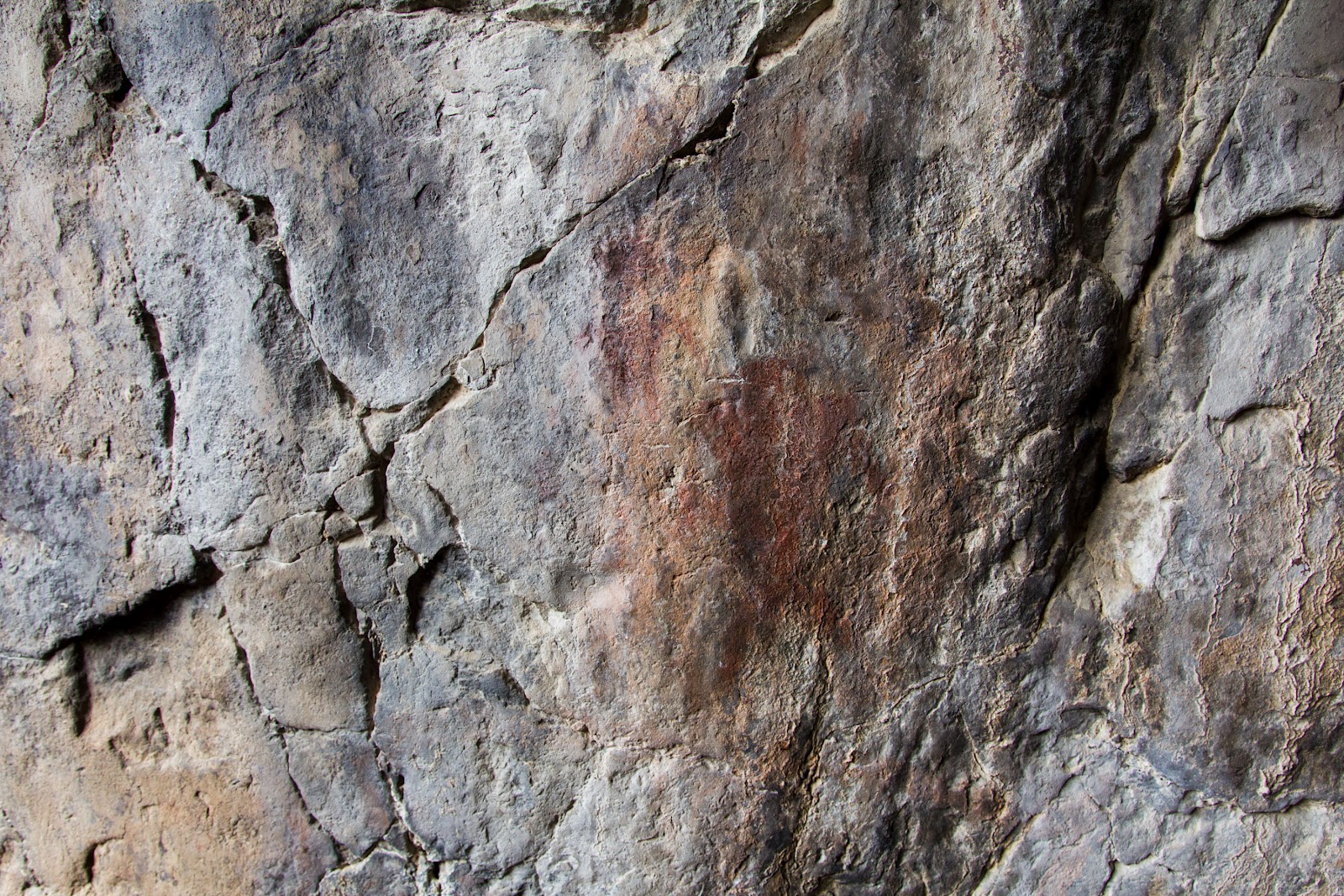
| "Superman" and other anthropomorph |
![]() |
| Double squiggle from Site 2 |
![]() |
| Site 2 Figure. |
Nearest City: Willard, UT
Location: N° W° The trailhead is on 7425 S. The sites will remain locationless for their protection.
Time Needed: Several Hours
Difficulty: Strenuous
Kid Friendly:
Additional Info: If you do go hiking above Willard, the mountains are known for rattlesnakes in the warmer months.
Location:
South Willard, UT, USA
Wednesday, February 15, 2012
The Spiral Jetty
Saturday we went out to the Spiral Jetty. I'd heard about it several times before, but had always heard that the road out there was bad. Actually, the people at the Golden Spike National Historic Site just down the road don't speak highly about the road to the Spiral Jetty either (Maybe it's just a National Park Service policy to make things sound harder than they actually are). We had no problems on the drive. In fact, any low clearance vehicle should have no problem with the road out there when it's in dry conditions. There were a few washboard sections, but it's a gravel/dirt road that is in great shape. To get there, go to the Golden Spike NHS, then follow the signs as you drive further west for another 16 miles.
We had the place to ourselves. The lake was high and we could just make out the shape of the Spiral Jetty under the surface. A few rocks on the stem were poking out. I wanted to walk out there, but then I reminded myself that it was February and the water would be freezing cold.
The sand is pretty cool too. It reminded me of the little balls of dry yeast that you use when making homemade bread. It's a special kind of sand called oolitic sand. Basically, instead of forming from rocks that have broken down into little pieces (like most sand), the oolitic sand is formed in the water from dissolved minerals. The minerals build up around a center made up of brine shrimp poo or something else.
We had a picnic, went on a walk on the beach, and skipped rocks. It was a relaxing getaway, especially with the kids sleeping in the back for the drive. I'll have to come back sometime when the water is warmer and go for a swim.
Nearest City: Corinne, UT
Location: N° W°
Time Needed: 2+ Hours
Difficulty: Easy
Kid Friendly: Yes
Additional Info:
We had the place to ourselves. The lake was high and we could just make out the shape of the Spiral Jetty under the surface. A few rocks on the stem were poking out. I wanted to walk out there, but then I reminded myself that it was February and the water would be freezing cold.
I had fun along the beach instead. We found a little salt bar that poked into the water. I say salt bar, because it literally was made up of salt crystals. See the picture below. It's awesomely crazy!
The sand is pretty cool too. It reminded me of the little balls of dry yeast that you use when making homemade bread. It's a special kind of sand called oolitic sand. Basically, instead of forming from rocks that have broken down into little pieces (like most sand), the oolitic sand is formed in the water from dissolved minerals. The minerals build up around a center made up of brine shrimp poo or something else.
We had a picnic, went on a walk on the beach, and skipped rocks. It was a relaxing getaway, especially with the kids sleeping in the back for the drive. I'll have to come back sometime when the water is warmer and go for a swim.
Nearest City: Corinne, UT
Location: N° W°
Time Needed: 2+ Hours
Difficulty: Easy
Kid Friendly: Yes
Additional Info:
Labels:
Box Elder County,
Free,
Northern Utah,
Random,
Utah
Location:
Spiral Jetty, UT, USA
Wednesday, March 16, 2011
The Brigham City Natural History Museum
The Brigham City Geology Museum is really cool. It's not very well advertised, and it's new location is a little off the beaten path, but it's open all of the time now instead of by-appointment. We were tipped off to it at the other Brigham City Museum and had to visit. It's definitely worth it
Fossilized lobsters and crabs are in display.

The baby turtle was really neat too.
There are several diplay cases of trilobites. The variety was quite astounding. Some were 1/4 inch long, while others were nearing 1 foot.
Fossil fish and leaves were there.
Some pyrite discs are thought to be fossilized sand dollars. The replacement was done with pyrite.
There were also several mineral displays. We only took pictures of a small portion of the museum.
Fossilized lobsters and crabs are in display.
The baby turtle was really neat too.
There are several diplay cases of trilobites. The variety was quite astounding. Some were 1/4 inch long, while others were nearing 1 foot.
Fossil fish and leaves were there.
Some pyrite discs are thought to be fossilized sand dollars. The replacement was done with pyrite.
There were also several mineral displays. We only took pictures of a small portion of the museum. Nearest City: Brigham City, UT
Address: 641 E. 200 N. Brigham City
Time Needed: 1 hour
Difficulty: Easy
Kid Friendly: Yes
Additional Info: This museum is located in an old elementary school in a residential area of town. It's open from 8-12 and 1-5 Monday through Friday. Free Admission.
Also- they have more exhibits to display, but don't have rooms and cases prepared to show them. Since they are operating on a thin budget, they are welcoming of donations and volunteers. Several rooms have been prepared as eagle scout projects.
Brigham City Museum
Friday we stopped by the Brigham City Museum. It had some neat exhibits of things from the 1800's.
In a case with some old guns was the wooden leg of a past citizen of Brigham City. There were several other displays and things to see.
The traveling/main exhibit though was pictures of Earth from Space, shown in conjunction with the Smithsonian Institution. Actually, we'd seen flyers on the exhibit, and decided to go see it. It was very cool to see several of the photos. The only complaint I had was that they didn't include scale bars as a reference for the size of the features highlighted.
In a case with some old guns was the wooden leg of a past citizen of Brigham City. There were several other displays and things to see.
The traveling/main exhibit though was pictures of Earth from Space, shown in conjunction with the Smithsonian Institution. Actually, we'd seen flyers on the exhibit, and decided to go see it. It was very cool to see several of the photos. The only complaint I had was that they didn't include scale bars as a reference for the size of the features highlighted.A few favorites:
The Lena River Delta.
A hurricane
The pyramids in Egypt.
Victoria Falls in Africa.
The Lena River Delta.
A hurricane
The pyramids in Egypt.
Victoria Falls in Africa.Nearest City: Brigham City, UT
Address: 24 N. 300 W. Brigham City
TimeNeeded: 45 minutes
Difficulty: Easy
Kid Friendly: Yes
Additional Info: Look at The Brigham City Museum Website for hours, etc.
Friday, November 12, 2010
The Wedding of the Rails
We took a trip out to Promontory Point to see the completion site for the 1st Transcontinental Railroad. There's not much out there! The site itself is pretty cool though. There's a museum and other things to see, and if the engines aren't out, you can always ask to go visit the roundhouse.
We had to ask to visit the roundhouse. The Jupiter and the 119 were inside getting worked on. One of the engineers came by and gave us a close-up look.

After seeing the engines, we drove out to do a short hike to the Big Fill. The crews from the Central Pacific and Union Pacific graded past each other, one making a trestle to the south of the big fill, the other taking longer to complete the big fill. After the rails were completed, the tracks were re-routed from the trestle to the fill.


We had to ask to visit the roundhouse. The Jupiter and the 119 were inside getting worked on. One of the engineers came by and gave us a close-up look.

After seeing the engines, we drove out to do a short hike to the Big Fill. The crews from the Central Pacific and Union Pacific graded past each other, one making a trestle to the south of the big fill, the other taking longer to complete the big fill. After the rails were completed, the tracks were re-routed from the trestle to the fill. 
We found several interesting things on our hike. The first one was an old nut from days gone by. Possibly from a train that went through. After taking pictures, we put it back on the ground for others to enjoy.

The second thing was also pretty small. We noticed a bunch of small circular rocks of uniform size on one of the grades. A closer look revealed countless fossilized shells, probably leftovers from Lake Bonneville.

We also did the eastern scenic drive along the railroad grade to the Chinaman Arch. It's a short detour, but the arch makes it worthwhile. At first it appears that there's not much out there, but having been there I can say there's more than meets the initial glance.

Nearest City: Corinne, UT
GPS Coordinates:
Time Needed: 2-3 hours
Difficulty: Easy
Kid Friendly: Yes
Additional Info:
Friday, October 29, 2010
The Rocket Exhibit
West of Corinne, Utah is Promontory Point- the completion site of the first Transcontinental Railroad. Nearby is ATK/Thiokol, the manufacturer of many of the rocket engines used in space travel and other applications. ATK has an outdoor museum of many of the products they have been involved in. Booster Stages for the Space Shuttle, Minuteman Missile components, Sidewinder Missiles, Geostationary satellites, etc. It's mindblowing.


Nearest City: Corinne, UT
GPS Coordinates:
Time Needed: 30 minutes
Difficulty: Easy
Kid Friendly:
Additional Info:
Subscribe to:
Comments (Atom)


