About Us

Showing posts with label Larimer County. Show all posts

Friday, September 24, 2010

The Gardens on Spring Creek

Yesterday we went for a visit to the Gardens on Spring Creek. It's a city owned garden, about half a mile south of the CSU Campus.


They have a flower garden, kids garden, fruit trees, and gardens with a sampling of crops grown in different areas of the world.


The fruit trees are all small right now, but in a few years will be quite impressive.
There is also a nature walk area with a small pond, native vegetation, etc. The lillys in the pond were really pretty.

Nearest City:Fort Collins, CO
Address: 2145 Centre Avenue, Fort Collins
GPS Coordinates:
Time Needed: 1 hour
Difficulty: Easy
Kid Friendly: Yes
Additional Info: Free* (Suggested donation $2 each, or $5/family) Gardens on Spring Creek
They have a pickup spot for free mulch/woodchips at the back of the parking lot. 1 Free load per day for homeowners.

The Cozy Cow Dairy

We had a little trip out to the Cozy Cow Dairy to watch the cows get milked. Unfortunately, we were too late. We'll have to go earlier next time.


There is also a little store where you can buy dairy treats such as ice cream, cheese, milk, eggs, etc.

There's a farm animal petting zoo on site as well.
Nearest City: Windsor, CO
Address: 28607 CR 17, Windsor, CO 80550
GPS Coordinates:
Time Needed: 30 minutes - 1 hour
Difficulty: Easy
Kid Friendly: Yes
Additional Info: The Cosy Cow Dairy Website

Thursday, September 9, 2010

Red Mountain Open Space

Red Mountain has been on my "to do" list for a while. Last night we had started out to get up there, but a storm rolled in just after we left Fort Collins, so we decided to try again later. This morning the skies were clear, so we drove up to see if Red Mountain was worth visiting. The drive to the trailhead goes through a pretty little valley/canyon. Off to one side was the old homestead of a settler long since gone.

We had the parking lot to ourselves, and started out for a hike. The north side of the Bent Rock Trail looked the most intriguing. A small stream ran down the bottom of a small canyon that began to cliff up.


The cliffs rose higher as we got further into the canyon, revealing the layers in the rock. It was really pretty. (sorry about the bad pictures, the sun was not in the most friendly location for pictures)

We weren't the only ones that liked the area. A few swallows had built their homes in nooks of the cliffs.
After the small canyon, the hiking turned into high desert hiking. The rabbitbrush was in bloom, but I found most of the remaining hike uninteresting. We turned north and looped back down the Sunset Trail back to the parking lot.

Nearest City: Waverly, CO
GPS Coordinates (trailhead): N 40° 57.483 W 105° 09.830
Time Needed: A few hours
Difficulty: easy
Kid Friendly: Yes
Additional Info: Red Mountain Open Space No Dogs Allowed. Restrooms are at the trailhead. Bring your own water.

Monday, August 9, 2010

The Fort Collins Water Works

Saturday was a tour day at the original Fort Collins Waterworks building. The building is owned by the Poudre Landmarks Foundation. They give free public tours the first Saturday of every month during the summer months.

The building and grounds are pretty cool. Currently the building is still being restored after being in disrepair for several years.
Out back are the remains of a stone wall that was used to hold back the water.

The inside is pretty cool too.
You just don't see the level of detail and craftsmanship anymore. Old buildings were built to be functional and beautiful at the same time.


There's a section of old wooden pipe outside too. Cool stuff!
Nearest City: Laporte, CO
GPS Coordinates: N 40° 36.930 W 105° 08.410
Time Needed: 1 hour
Difficulty: Easy
Kid Friendly: Yes

Monday, August 2, 2010

Zimmerman Lake Backpacking

We took off Friday for a short backpacking trip to Zimmerman Lake. Zimmerman Lake is up Poudre Canyon almost to the top of Cameron Pass. It took us nearly an hour and a half to drive to the trailhead from Fort Collins. It was raining when we arrived at the trailhead, so we waited in the car for the rain to pass.

Fortunately, the time wasn't wasted. We saw a female moose browsing on a hillside across the highway from the trailhead.
We set out, and were amazed at the many beautiful wildflowers and mushrooms.

The clouds parted shortly after we arrived at the lake to set up camp. The hike in is along an old logging road and is only a mile. Campsites are available on the west and east sides of the lake.

There are also several lumber piles in the area- remnants from logging back in the day. We saw one along the road, and 2-3 more to the east of the lake.

The lake was really pretty about sundown when the breeze stopped and it got glassy. We could hear splashes from several greenback cutthroat trout jumping.

We enjoyed dinner and sat around the fire before we we retired to our tent for the night.
The next morning, we hiked to the top of the ridge southeast of camp (two pictures back). There isn't a trail, so we bushwhacked our way to the top. The views were incredible!

We wandered back down the mountain, enjoying the beauty of the many wildflowers as we hiked.

As we hiked down the road to the trailhead, we talked about how lucky we were to have avoided any serious rain. What a great short backpacking trip!
Nearest City: Laporte, Co
GPS Coordinates: N 40° 32.345 W 105° 52.935
Time Needed: 2 hours roundtrip, including time at the lake
Difficulty: Easy
Kid Friendly: Yes
Additional Info: The trail is an old logging road. Bring your fishing pole and try to catch greenback cutthroat trout in the lake. Restrooms are available at the trailhead.

Monday, July 26, 2010

Crown Peak & Crown Point

Saturday we bagged a few peaks up Poudre Canyon. We started at the Browns Lake Trailhead and climbed Crown Point and Crown Peak. The trailhead is 12 miles up the Crown Point Road, which is 4 miles up the Pingree Park Road from the main highway. It's a good dirt road and easily accessible with low clearance vehicles. The trailhead has space for about 20 cars, and we were surprised at how full it was when we got there.
The trail goes to Browns Lake, but there are two peaks which are slightly off trail. You can see a lower summit of Crown Point from the parking lot, but the higher peak is slightly further. The trail passes within a couple hundred yards of it. We had lunch at the peak.
Our original destination was just Crown Point, but then we checked the time, and decided to go on to Crown Peak since we weren't in a rush to get back to Fort Collins.

We're glad we pressed on. We hiked back down to the trail, then followed it and crossed the wilderness boundary to the Comanche Peak Wilderness as we decended into a small valley. From the top of the other side, we could see Crown Peak again, so we left the trail again to hike cross country to the peak. There's not a trail to the peak, so you just go wherever.


About 1/4 mile from the peak, we watched as a horse came over the rise. The horse had a halter, but nothing else. Apparently someone lost a horse up here and it found itself at home above timberline on the high tundra. The horse walked to within 50 yards of us, and continued on down the slope.

We continued on to the peak. We summited out at 11,711 feet. It was fun to enjoy the summit and look all around at the amazing views.
After about 10 minutes of resting at the summit, we turned around and headed back down the mountain.

We hiked about 5 miles and gained about 1500 feet in elevation in about 4 hours. It was a great little hike.

Nearest City: Laporte, Co
GPS Coordinates: N 40° 38.990 W 105° 41.894
Time Needed: 4 hours
Difficulty: Moderate
Kid Friendly: Doable with kids. It may take additional effort on your part though.
Additional Info: After we made it back, I heard that there is a crash site of an old bomber in the vicinity of Crown Peak. You may want to find additional information and go check it out.

Monday, July 19, 2010

The Colorado State University Art Museum

We stopped by the CSU Art Museum on Friday night. It's a short walk from our apartment, and seems to be new on campus. The museum is in the old Fort Collins High School building, across the street from the CSU flower gardens.


Right now the main exhibit is on Pacific islander art, but the lady a the front desk said that the exhibits will change every 3 months or so.

I liked the canoe.


This head was kindof creepy.

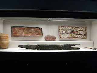
They also had some miscellaneous other pieces.
The museum is really small and took us 30 minutes or so to casually look at everything.
Nearest City:
GPS Coordinates:
Time Needed:
Difficulty:
Kid Friendly:
Additional Info:

Friday, July 16, 2010

Climbing and Rappelling at Duncans Ridge

Duncan's Ridge is a popular climbing area near Fort Collins, overloooking Horsetooth Reservoir. Although there are numerous bouldering areas nearby, Duncan's Ridge is the closest and easiest access for those who want to toprope.


There are several routes that have been bolted up top. I counted 3 while doing a quick check.


Park at: N 40* 32.085 W 105* 08.560
Cross the street then follow the trail up the hill.
Climb at: approximately N 40* 32.000 W 105* 08.685
Nearest City:
GPS Coordinates:
Time Needed:
Difficulty:
Kid Friendly:
Additional Info:

Tubing the Poudre River- The Town Run

Tubing the Poudre is one of the great summertime things to do here in Fort Collins. The two options are either head up the canyon, or take to the river right here in town. The run up the canyon is longer, but it's not as convenient as the one in town.

The best place to start is at the bridge on Shields Street. There are plenty of parking spaces along the road. Some people walk upstream from the bridge before they get in, but it's easiest to launch just down from the bridge.
Much of the float is like a lazy river, but there are enough small rapids to make a few spots interesting. I've found that the best approach to a clean float through the rapids is to stay slightly off of center away from the side with the branches and other obstacles.
The float passes under two pedestrian bridges along the north edge of Lee Martinez Park and past a few rope swings. There's a dam a hundred yards or so past the second bridge, so it's best to get out at the second bridge. Trails on both sides of the river lead back to the top where you can start all over again.
Nearest City:
GPS Coordinates:
Time Needed:
Difficulty:
Kid Friendly:
Additional Info: