About Us

Showing posts with label Wild Berries. Show all posts

Thursday, September 24, 2015

Wild Blackberries in Kansas

July is when blackberries start to ripen in Kansas.  We were out and about over the winter and discovered a patch or two, so since mid summer was here, we headed out to see if we could find them again.  Some patches didn't have any berries, but two of them did! We plinked them into our buckets and mouths.  Blackberries are delicious!  On the way home we picked up some ice cream to make blackberry shakes.  They were so good, we went out and did it again the next week after some more berries had ripened.


Nearest City: Lansing, KS
Location: ???
Time Needed: varies
Difficulty: dodge thorns and poison ivy for to get the goods!
Kid Friendly: yes (tasty treats) and no (thorns and poison ivy)
Additional Info:

Wednesday, July 29, 2015

Wyalusing State Park: Caves, Raspberries, and Indian Burial Mounds

I took the week of the 4th of July off from work. We decided a few months before to go to Wisconsin and Minnesota for our big summer trip.  We originally had planned to drive up I-35 through Minnesota, visit Lake Superior, then work our way down through Wisconsin on the way home.  About 10 days before the trip though, a good friend called up and made a pretty convincing case to do the trip the other way.  He and his new bride were going to be in Minnesota for the 4th, and if we were there for the last weekend of our trip instead of the first, we'd be able to meet up.  So, we flipped the trip around and spent the first day driving diagonally across Iowa.  I do have to say, Northeast Iowa is beautiful.  It's known as the Driftless Area because it was not covered by glaciers in the last ice age, and as such it was not ground flat by all of the ice.  Instead, it's full of canyons and large bluffs, especially along the Mississippi River.  
We wanted to visit Effigy Mounds National Monument, but since the monument doesn't have camping facilities, we stayed at Wyalusing State Park, across the river in Wisconsin.  It was a fortuitous choice.  After visiting Effigy Mounds and Wyalusing, if given the chance again, I'd spend more time at Wyalusing.  We nabbed one of two remaining campsites in the campground when we arrived.  Although it's a developed campground, many of the sites have thick brush undergrowth isolating them from the neighboring sites.  Fireflies were flickering as we set up camp and piled in, exhausted from hours of driving.
Wyalusing means "home of the warrior" in Lenape, a native language.  I personally think the park is misnamed, since the indians regarded the confluence of the Wisconsin and Mississippi Rivers, located just below the park, as neutral ground that was for trading and peaceful talks instead of a battleground.  European explorers came through the area, beginning with the famous expedition of Marquette and Jolliet in 1673.  Jacques Marquette, a Jesuit priest, and  Louis Jolliet, a French-Canadian explorer, left on their journey, which took them across Wisconsin from Green Bay, up the Fox River, then down the Wisconsin River to the Mississippi River.  They were the first Europeans to explore the upper Mississippi River- traveling  nearly to the Gulf of Mexico before returning.   They passed through here on June 17, 1673- approximately one month into their four month journey.
We had our own explorations to make.  We went to look at some indian mounds.  There are several mounds in the park.  We stopped and walked around some bear effigy mounds.  There are also mounds shaped like deer, birds, and turtles in the park.  The mounds are really subtle- just a low 2-3 foot difference in height from the surrounding land.  I was walking around the bear mound, trying to figure out where the head was when a shout from the kids stopped me.  They had noticed some black raspberries just off of the edge of the mowed lawn.   We enjoyed nature's abundance and ate our fill of the delicious berries.  The next morning we found some more and ate them with our pancakes.
We took a short hike to see Treasure Cave.  The cave is down on the side of the hill, and the trail passes through an arch along the way.  The kids noticed lots of small frogs along the trail, so we stopped and picked a few up to look at them closer before continuing on.  There are stairs down to below the cave, then a steep climb up some stair/ladders to get to it.  Up we went.  
The cave was about 25 feet deep and had a nice blast of cold air coming from it.  I crawled down the tunnel to a small room that had been dug out by earlier visitors.  The room was a dead end.  I turned around and nearly back at the entrance noticed the airflow pick back up.  It came from the side of the tunnel, blowing from a crack about 2 inches wide.  Judging from the air flow, there's got to be a pretty decent cave system in there, but it's not accessible from Treasure Cave.  
We enjoyed several other walks and especially the overlook of the Mississippi and Wisconsin Rivers. One of the evenings we were there we took the kids down to the showers.  A hot shower when camping is a nice luxury.  The kids screamed and yelled and had a great time playing.  I had a few good conversations with other campers as they remembered camping trips with their children.  Wyalusing was a great beginning to our Wisconsin vacation.

Nearest City: Prairie du Chien, WI
Location:  13081 State Park Ln, Bagley, WI  53801
Time Needed: 4 hours, minimum
Difficulty: easy
Kid Friendly: yes
Additional Info: Wyalusing State Park Website.  The campground has hot showers.

Tuesday, July 28, 2015

Hooray for Mulberries!

In late May and early June we had a great time picking mulberries.  Here in Kansas, they're just about everywhere.  They're in the city, staining the sidewalk purple, or along the back alley ignored by virtually everyone.  They're in the country too, most commonly along fence lines and dirt roads. 
Most people don't know that they're edible.  They're ripe when they're almost black and  quite frankly, you could spread out a tarp under a tree and shake it and they'd fall off and make picking easier for you.  They look kindof like blackberries or raspberries, but instead of growing in a bramble, they grow on trees.  The berries also have a small green stem, while raspberries and black berries do not. The stem is edible.  We picked quite a few.  Mostly we picked them here and there and ate every berry we picked almost as soon as it was in hand.  One Saturday we did find a tree that was heavily laden, so we spread out some sheets underneath it and did give it a good shake.  We ended up with enough berries to go home and make some jam, as well as a pie or two and bag a few bags for our freezer.  That was a good day.  What do mulberries taste like?  They're sweet but without any tartness.  They taste somewhat like a blackberry or a raspberry if you subtracted the tartness or tang.  They're not quite as good, but they're delicious nonetheless.  One of the best parts about them is the fruit ripens over a several week window, so you can go back several times to pick them.  I think that's part of why they're not really available in stores.  One of our favorite things to do with mulberries other then eat them raw, is to bake them into a pie with cherries to make a cherry-mulberry pie.  Sometimes pie cherries can be too tart, so the mulberries counter the tartness to result in a delicious pie.  Next year go ahead and pick them.  You've seen that tree staining the sidewalk way too many times.  You'll be glad you did.

Incidentally, mulberry trees were imported to North America to provide food for silk moths.  I've never seen a silkworm on a mulberry tree though.
Also there's a nursery rhyme about a mulberries. All around the mulberry bush the monkey chased the weasel.  The monkey thought it was all in fun POP! goes the weasel.  Consequently, I tease my kids when we pick mulberries that I'm looking for a monkey and a weasel. 

An Easy Walk to Angel Falls

We found another enjoyable trail to walk and bike.  The Angel Falls Trail is in Lansing, Kansas and leads to a small waterfall on Sevenmile Creek.  Usually we just park at the Catholic Church that is on the corner and follow the trail down.  Lansing City has been doing some trail improvements and now there's a paved walkway that goes from Ida Street all the way past the falls and out to Mary Street. 
Angel Falls only drops about 3 feet or so where Sevenmile Creek crosses a ledge of harder bedrock.  There are fossil shells and crinoid stems in the rocks if you're interested in fossils as well.  We left the trail and made our way down to the waterfall to splash and play in the creek.  We've gone to Angel Falls a couple of times since it's a walk that's the perfect length for kids to do.  In May and June there are a few mulberry trees that grow along the trail, so we picked and ate a few mulberries.  I do have to admit that whenever I eat mulberries, I think of the nursery rhyme and start looking for a monkey and a weasel. 

Nearest City: Lansing, KS
Location: Trail begins off of Ida Street and 147th Street
Time Needed: 45 minutes
Difficulty: easy
Kid Friendly: yes
Additional Info:

Tuesday, February 24, 2015

Canoeing at Bernard Park in Lansing

Several months ago when we knew that our time in Arizona was drawing to a close, my wife and I talked about some of the things that we hoped we would find in our new community.  I do have to admit, one of the greatest wishes for me was water for fishing and canoeing.  A nearby trout stream was crucial therapy during my teenage years, and I admit that for several years I sought therapy multiple times a week.  I tell my wife that she is my true love, but that fishing was my first love, and one of the amazing things about my wife is that she understands.  She calls it my obsession, or one of them. She enjoys fishing too, but as "part of this complete breakfast" of fun things to do outside. 

One of the things we enjoy doing together is canoeing.  We had the Green Monster, our first canoe, when we lived in Fort Collins, Colorado.  It was an old fiberglass canoe that I found for $50 on craigslist.  It had a few cracks and holes in the hull after being brutalized by falling branches from a windstorm.  It wasn't pretty when we first got it, but the price was right for our newlywed budget.  A little bondo and some fiberglass cloth and epoxy made it seaworthy and a great vehicle for our enjoyment of Northern Colorado outdoors.  We took it to several of the ponds and lakes in Fort Collins for afternoon paddles, floated down the Poudre River on it, and even took it on an overnight canoe trip.  Our first child loved standing up in the front as we paddled along, then slept on a blanket spread on the bottom for naptime.  We had some great times and have some awesome memories in that old beater canoe.  We sold it when we left Colorado for a new job and didn't quite know what our living arrangements would be. 

After we got settled in Utah, we started to miss our canoe, so I looked around and found a red canoe that was a little newer and a lot nicer.  We had some good times taking it to the several ponds in the county, as well as hauling it up to the Bear River for a few day trips.  The oldest still loved going out on it, but #2 would get nervous from the rocking boat and the restrictive life-jackets.  Still, it made for a great afternoon whenever we'd load the canoe up and go for a paddle.  A hiccup at work forced us into re-evaluating my career path,  so we sold the canoe and moved to Arizona.  We knew there wouldn't be many places to paddle, and thought we could find a canoe there if we needed to.

After we got to Arizona, I missed fishing, and we missed having a canoe, but we sure had fun running around in the desert.  There just wasn't anywhere close enough to justify buying a canoe.  Deep down though, we both knew that we weren't done.  Another canoe was waiting for us somewhere.  I started to put plans in place to build one. 

The way forward proved to be a career advancement that required yet another move.  We uprooted our growing family and moved to the Midwest.  We'd never lived far from the mountains before, but better opportunities were here, so we picked up and moved.  We hadn't been here long before I started looking around for a canoe.  I found one for a good price, and bought it and hauled it home late on Christmas Eve.  The kids sure were surprised when they saw the yellow boat sitting outside on Christmas morning! 

We took our newest canoe out for it's trial voyage in late December at Kenneth W. Bernard Park in Lansing.  There is a small pond there that wasn't frozen and was open for a paddle.  We had a blast paddling back and forth from one end to the other.  It wasn't an epic canoe journey, but it didn't need to be.  I'll take open water in December!  I think future canoe trips here will include fishing poles and we'll take the opportunity to float around and try to catch a few fish. 
Bernard Park is a great little outdoor playground.  We've discovered a lot there on our several visits.  There's a network of hiking and mountain biking trails that loop around the park in addition to the pond.  We've been back since and taken the trails back into the woods and along a couple of small creeks.  There's a few scraggly looking blackberry plants here and there along the trail that I hope will have juicy berries on them this summer.  An osage orange tree really had the kids wondering why the round balls looked like rotten oranges.  The kids wondered if any animals lived in a hollow log.  We really like Bernard Park.  Even when we haven't done a big walks or explored, the kids have had fun just playing on the playground.  As the weather warms up more, we'll definitely enjoy visiting it in the different seasons. 

Nearest City: Lansing, KS
Location: 4-H road, west of Lansing
Time Needed: varies
Difficulty: easy
Kid Friendly: yes
Additional Info: Lansing, KS Webpage

Saturday, January 24, 2015

All alone at the Marais Des Cygnes Massacre Site


We took a short trip down south just after Christmas.  It looked like a nice weekend, so we loaded up and headed out.  We drove out of Kansas City and toward Fort Scott.  We didn't have any particular schedule to keep, but we had several sites to visit along the way.  Our first stop was at the Marais Des Cygnes Massacre Site.  
The site is located a few miles east of Highway 69, about an hour south of Kansas City.   It's only about 1/4 mile from Missouri, which plays a factor in the story of the Marais Des Cygnes Massacre.  It's relatively undeveloped for being a State Historic Site, with a few picnic tables, an old historic "cabin" that's apparently always closed, and a short driving tour with signs to read telling about the massacre.  There are numerous pecan trees, but all of the pecans we cracked open had been eaten by bugs.  A few blackberry bushes pop up along abandoned stone fences.  It's literally a place that you'll most likely have to yourself if you visit. 

The Marais Des Cygnes Massacre was part of the "Bleeding Kansas" struggle prior to the Civil War.  Bleeding Kansas was essentially a political struggle from 1854-1861, centered primarily on whether Kansas would permit or oppose slavery.  The tendency was to oppose it, but citizens of pro-slavery Missouri did their best rail against anyone against slavery, and sometimes the efforts fell to violence. 
The Marais Des Cygnes Massacre was one of the last large violent outbreaks of the Bleeding Kansas era.  On May 19, 1858, a group of 30 or so men from Missouri crossed the border into then Kansas Territory and rounded up 11 unarmed men and turned back east.  Most of them knew the leader of the group, Charles Hamilton, personally.  Hamilton and his ruffians led them into a small hollow, then opened fire.  Five of the men were killed, five were injured, and another escaped physical harm by playing dead.  The only man who was prosecuted for the crime was caught and hanged in 1863. 
We wandered the area for a while. There's a prominent spot in the ravine where a plaque or statue must have once been attached, but now it's just an empty cement monument base.  We turned to walk back to the car, but got sidetracked with one of the stone fences.  There's lots of limestone in the area, and several fences have been constructed of the stone. 

We noticed several fossils in the stones- this a small fossilized piece of crinoid stem.  It's an interesting spot.  We spent probably 45 minutes at the site, reading the signs, wandering under the trees, and swinging on a small rope swing dangling from one of the oaks.  It would be a great spot for a picnic!

Nearest City: Lacygne, KS
Location: North of Kansas Hwy 52, 1/4 mile east of the Missouri state line
Time Needed: 30-45 min
Difficulty: easy
Kid Friendly: yes, but not that entertaining to them
Additional Info: Kansas Historical Society Webpage

Friday, October 31, 2014

Fall Leaves in the West Fork of Oak Creek

On Columbus Day we woke up, enjoyed breakfast, then headed out to go hike the West Fork of Oak Creek. We stopped by there a few days earlier and went and visited Pumphouse Wash instead because of the crowds.  We thought that a Monday would be a better option, since getting there early would mean we could park at the trailhead. 
We arrived about 8 and found the parking lot about 1/4 full.  We paid our $10 parking fee (or $2 for walk-ins), parked, then loaded up.   A bridge crossed Oak Creek, and we could see a few trout swimming in the pools below.  Thick blackberry brambles along the bank would make for a tasty treat earlier in the year, but now they were all bare. At the mouth of the canyon, we found the ruins of an old lodge.  I can't remember much about the lodge other then it being just about the first building in Oak Creek Canyon.
We explored the nearby chicken coops and "cave", a room cut into the sandstone cliff.  Then we ducked into the canyon.
The trail goes a little over 3 miles, and 13 stream crossings up the West Fork of Oak Creek.  We brought sandals and water shoes but didn't need them because the stream was shallow enough to hop across and keep dry feet. 
Most of the way we found the canyon pretty quiet.  It's a narrow canyon, but it never really gets to be as narrow as a true slot canyon is.  The water and the sandstone sure are a pretty combination though!
Does this remind anyone of another famous picture spot?  The log propped up against the overhanging canyon wall reminded me of the numerous pictures I've seen of "The Subway" in Zion National Park.
There aren't any waterfalls in Oak Creek Canyon, but a there's a few spots, like this one, where the stream has cut into the sandstone bedrock, forming small plunge pools. 
More sandstone, water, and fall leaves.   We were a little bit early for peak color.
At the end of the trail, there's a large ledge overlooking the creek.  It's a very popular spot to stop, eat a snack or lunch, then turn around and hike back down the trail.  People aren't the only ones that like the spot.  This crow was entertaining the crowds when I got there.  He evidently has learned that there is food where there are people sitting down. 
The maples were starting to change color, but were far from being ideal.  It was still a beautiful little hike. 

Nearest City: Sedona, AZ
Location: N° W°
Time Needed: 1/2 day
Difficulty: easy-moderate
Kid Friendly: yes
Additional Info: watch out for poison ivy.  It's there in abundance, but none of the signs at the trailhead warn you about it.

Saturday, August 9, 2014

Catching Frogs at Hidden Lake

We had a quick trip to Utah to attend my sister's wedding.  While we were there I was able to get out and do some hiking in the Uintas.  We debated between going to Hidden Lake and catching frogs, or going to Smith and Morehouse to play in the water, go fishing,  and find wild raspberries.   Either option sounded great to me, and that was the case with pretty much everybody else, so we packed a lunch and went to find frogs at Hidden Lake. 
Hidden Lake is located above a private cabin area up Weber Canyon above Oakley.  It's closed to the general public, but since we have friends who live in the cabin area, they've invited us to come up a couple of times during the summer.  (During the winter, they have to take snow machines in because the roads aren't plowed).  We hiked in to the lake, but it's accessible by a 4-wheeler trail for those with the bigger toys. 
Hidden Lake is a small lake, maybe a couple of acres.  We had a picnic on the shore, then wandered up and down the banks looking for frogs.  We found and caught a lot of frogs- with up to 4 being in temporary captivity at once.  A lot more of them jumped into the lake and swam away to defend against getting caught.  We even found a small snake.  We'd hold the frogs, then let the kids hold them and turn them loose into the water.  It was a lot of fun. 
Toward mid afternoon we could see some storm clouds gathering, so I took a quick hike around the lake to look for wild raspberries.  Typically I've had the best success finding them right around Labor Day, so even though it was early for them I still wanted to look.  I found a nice patch just south of the lake and a quick canvass turned up about a dozen red raspberries.  It was still a little early, but those few berries were sure good!  When I got back from my 0.4 mile (according to the sign at the NW side of the lake) hike around the lake, we packed up and headed down the hill.  A couple hundred yards before the cars the rain started to come down, so we picked up the pace and were glad we'd made it back just in time to escape one of those classic summer deluges the Uintas are known for.

Nearest City: Oakley, UT
Location: Hidden Lake Association up Weber Canyon from Oakley
Time Needed: a couple hours
Difficulty: moderate
Kid Friendly: yes
Additional Info: Hidden Lake is a private home/cabin owners area.  No Trespassing without permission.

Tuesday, June 17, 2014

Hiking Over and Through Tonto Natural Bridge

Tonto Natural Bridge is a pretty amazing place.  It was discovered by David Gowan, a prospector, who tangled with some Indians in a bad way and needed a hideout.  As he was running, he stumbled into the canyon with the natural bridge, then hid out in the caves near the base of the bridge for a few days until the Indians left.  Artifacts found in the area pretty clearly show that the Indians knew about the bridge prior to that, but it was probably a different group that chased poor Mr Gowan.  At least, that's how it makes sense in my head.  Otherwise they would have probably captured him, leaving it up to the next person who happened upon the bridge to gain the notoriety of being the person to bring it to the attention of others.  Mr Gowan was not captured, and later talked his nephew into coming back with him to the area where they ended up opening a resort of sorts.  Fast forward a few decades or so and now the area is Tonto Natural Bridge State Park. 
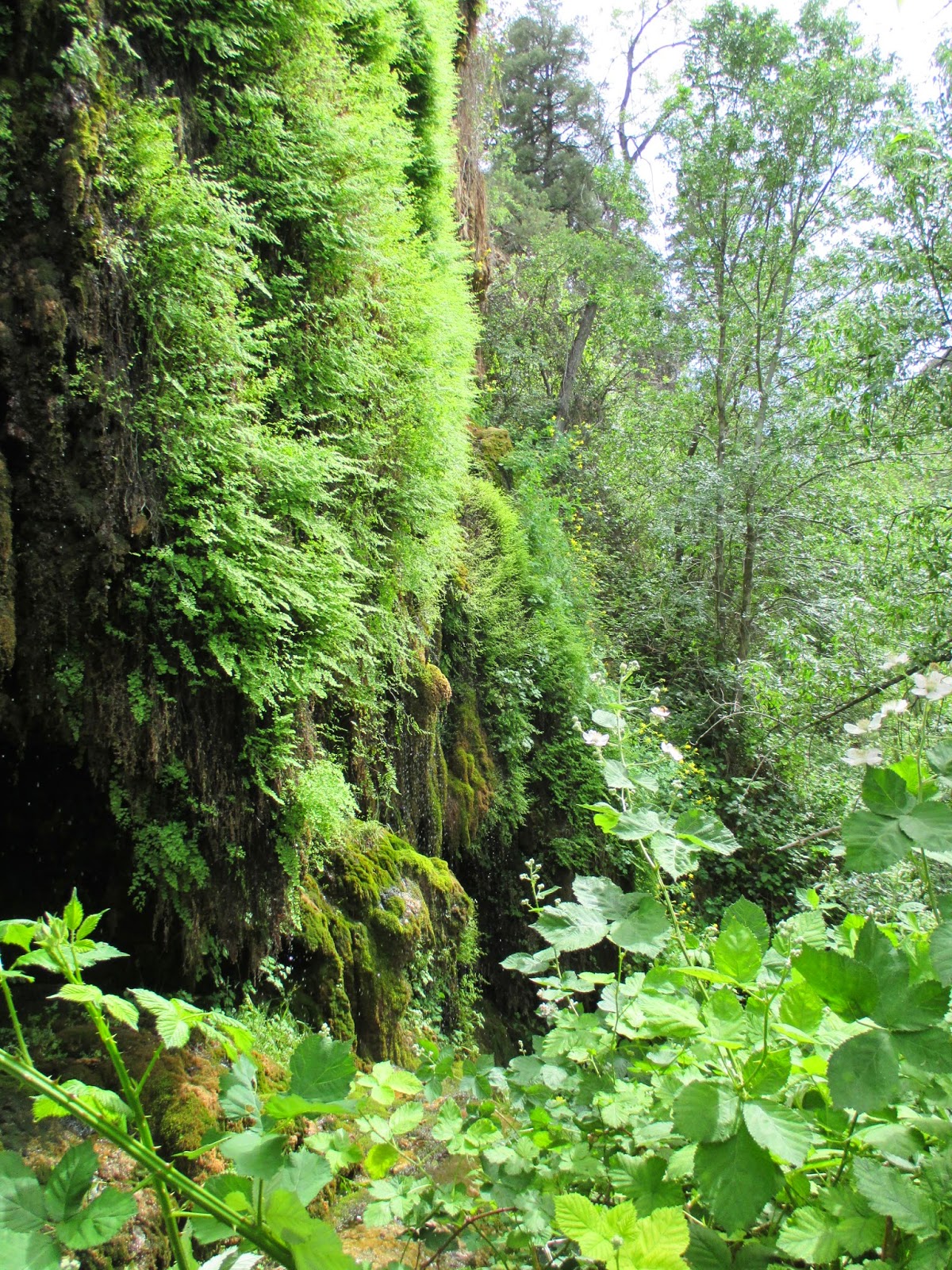
The bridge is massive. Gigantic.  Huge.  Awe inspiring. Difficult to capture with a camera. Possibly the largest travertine bridge in the world.   Located down a very steep grade from the highway.  All of the above.  We stopped at the nearby lodge that was converted into the park headquarters to pay our entry fee.  Among the artifacts that had been found in the area, a buck skull caked with travertine caught my eye.  We continued to the parking lot, then got out to try and see where this bridge was.  As we wandered and looked, we turned the corner to a viewpoint and discovered that we had been walking over the top of it and hadn't been aware of it.   
We picked our way down the trail on the up-stream side of the bridge.  We stopped every now and then to admire the bridge, as well as the travertine deposits along the walls.  To me they very much looked like cave formations, formed because of the high mineral content of the water and a flow rate high enough to counter the drying out that comes from evaporation.  At the bottom of the trail, we turned west and hopped down stream to try and get a better look at the bridge.  The viewpoint from here is better than it is on the other side.    
As we were picking our way over the rocks and boulders, we found a sign with an arrow pointing the way, then another one, and pretty soon we found ourselves underneath the bridge.  Every time we lost the wayfinding signs, we'd look a little harder and find another one soon enough.  Pretty soon, we'd climbed all the way through the bridge and were on the other side.  The signs on the downstream sign warn hikers to not climb in the upper caves, or swim in the pools underneath the bridge. 
There's a  cascade of water that pours down the top of the bridge, making the downstream side richly decorated with green mosses and other water loving plants.  We looked and had a great time gazing up at the expansive bridge.  The hike up took a lot longer than our hike down to the bridge.  We passed a few hikers that had dogs with them and had blatantly disregarded the signs saying to not take dogs on the trail. 
We then did the short "Waterfall Hike".  The Waterfall Hike doesn't really have a waterfall on it.  Instead it's a lush green travertine cliff that's seeping full of water and covered in ferns, mosses, columbines, and other plants.  It's neat, but definitely steep stairways to climb.  There were a lot of wild blackberry plants that made me think that late summer might be a good time to visit here.  We definitely had a good time at Tonto Natural Bridge. 

Nearest City: Payson, AZ
Location: N° W°
Time Needed: 2-3 hours
Difficulty: varies
Kid Friendly: yes
Additional Info:

Monday, June 16, 2014

Beaver Creek Picnic Area

We had planned on driving through Oak Creek Canyon and Sedona after leaving Flagstaff, but the Slide Fire was pumping an inordinate amount of black smoke into the sky and highway 89A was closed, forcing us to change our plans.  We took I-17 south instead, and took the Sedona exit, but headed east.  Our map had the Beaver Creek Campground nearby, so we thought it might be a good place to find a campsite.  As luck would have it, the Beaver Creek Campground was closed a year or two ago due to flash-flood danger, and now is the Beaver Creek Day Use Area. I pulled out my National Parks Pass and the manager still wanted $10, or I could go to the free area across the street.  I'm not a sucker, so I drove across the street to the free area.  It turned out that the Beaver Creek Day Use area, while owned by the Forest Service, is leased for management by a private company.  They charge $14/day or $10 in the late afternoons.  No thanks. 
The free picnic area would end up being a frequent stop for us throughout the rest of our trip.  We found a primitive campsite nearby out in the desert, so we'd stop and cook meals here and let the kids play and splash in the creek.  They had a blast splashing, looking for crawdads, and playing in the water.  My wife had fun looking for pretty birds in the trees (a few birdwatching groups came by while we were there).  I wished I had brought my fishing pole when I saw a few trout swimming around.  We even saw some blackberry plants along the creek.  Higher up the creek there are some fantastic swimming holes with red sandstone cliffs to jump in off of.  The V-Bar-V petroglyph site is nearby and ended up being a fantastic addition to our trip as well.  If you're driving  along I-17 and need a good stop for the kids, this is a great place for a break!

Nearest City: Sedona, AZ
Location: Take Exit 298, then drive east on road 618 for a 2-3 miles.  The picnic area is on the left where the road crosses the creek. 
Time Needed: varies
Difficulty: easy
Kid Friendly: yes
Additional Info:

Friday, October 4, 2013

Family Backpacking trip to Aravaipa Canyon complete with Bears!

I'm finally getting around to updating a trip to Aravaipa Canyon we had in May.   Late May is a perfect time to visit Aravaipa.  Summer hasn't officially kicked off, so lots of families still have kids in school, but the weather is perfect.  I reserved a few permits to go in the East end, and we made it happen.  We left Sierra Vista after work on Wednesday, and drove to a primitive campsite on Turkey Creek right at the east end of Aravaipa Canyon.  The official trailhead is 1 mile or so east of Turkey Creek, but there are some amazing campsites up the side canyon, and it's a shorter hike, so camping at Turkey Creek before heading out on our backpacking trip made a lot of sense.  I counted 11 stream crossings we had to drive through to get there though.  Most of them are not bad at all if you have a little clearance on your vehicle.  I wouldn't recommend driving a sedan.
We got up on Thursday morning, the first day of our permit, had breakfast, picked up camp, made sure we had everything we'd need in our packs, then headed out!  There's no reason to try and stay dry because the trail for much of the time is in the creek.

The contrast between the streamside riparian area and the desert vegetation higher on the hillsides is really fascinating.  Not many cacti are in the streambed because they will rot if they have too much water. We hiked about 2 miles or so to a great campsite where Deer Creek enters in from the north. 
After setting up camp and jettisoning most of our loads, we put on our daypacks with some snacks and water and hiked up Deer Creek to the slot canyon.  Most of Aravaipa can't truly be called a slot canyon, but a ways up Deer Creek definitely fits that definition with the narrow water-sculpted walls.  On the way up, we found a friendly little tree frog that the kids didn't want to leave behind.  We left him and said we'd look on the way back for him. We also saw a few wild blackberry plants that would be fun to forage later in the summer.
The Deer Creek walls got narrower and narrower until finally we could touch both at the same time.  Fantastic!  More!  More! 
But all good things must come to an end, and with kids clamoring for dinner, I turned around to go back to camp and to feed a few hungry little ones.
Here's a picture of the campsite where Deer Creek meets up with the main Aravaipa Canyon.  Fantastic.  Somewhere in here is a lost Gerber pocket knife that slipped out of my pocket.  I had a lot of good adventures with that knife and still miss it
Friday we splashed our way back up the creek on our way out.  We only saw one or two other hikers, a result of the permit system that restricts access to the area.

Back at our Turkey Creek campsite, we went and looked for the Turkey Creek Ruin, constructed by Salado Indians a couple hundred years ago.  We finally found it.  It's not hard to find once you know where to look.  Going up-canyon, you drive through an old corral, after the corral, drive through the streambed and up the small hill on the other side, then park on the right side.  There are a few signs and a short trail to the ruin.  Fantastic!  It's a neat little cliff dwelling. 
Turkey Creek Canyon is an amazing canyon itself.  I really liked the sycamores, walnuts, and other trees.  We camped another night there on Turkey Creek.
Saturday morning, I got up before anyone else and went on a walk.  I walked down the canyon to Aravaipa, then up the road to a stream crossing.  As I turned to retrace my steps, I found that I was cut off from camp by a momma bear and two babies right where Aravaipa Creek and Turkey Creek come together!  I watched them for a while, then ran to get the camera.  They were pretty skittish and the cubs ran up a tree as soon as I let them know I was there.  Momma soon joined them.  It was the perfect way to cap of an unforgettable backpacking trip.


Nearest City: Klondyke, AZ
Location: N° W°
Time Needed: At least 2 days
Difficulty: Easy as far as backpacking goes
Kid Friendly:
Additional Info: