About Us

Showing posts with label Northern Arizona Road Trip. Show all posts

Saturday, October 25, 2014

The Sedona Model Airplane Club

Hot Air Balloon at Sunrise over Sedona
Back over Columbus Day, we took a trip up to Sedona.  My wife needed to get out of the Sonoran Desert, she didn't put it that way, but that's all it was.  She said "I just need to get out of Arizona- New Mexico, Nevada, California- I don't care where we go, I just need to leave Arizona."  So we started to weigh our options and destination possibilities.  I didn't want to go particularly far since it was a short holiday weekend, so as we discussed possible destinations, nothing really meshed with both of us until we mentioned Sedona as a possibility. 

Back in May we had our Northern Arizona Trip (see the Northern Arizona label for much of what we did), but the Slide Fire just west of Oak Creek Canyon started after we left, and the resulting blaze closed the canyon and Highway 89A to everyone but the firemen, and forcing us to re-arrange our trip and discover new things to see and do.  It was a serendipitous closure for us because we found some really great spots, but we wanted to come back up and see what we missed.  We left Sierra Vista on Friday after work and drove for 5 hours, arriving in the vicinity after dark.  We took a few dirt roads and found a great little campsite where we hurridly set up camp then crashed for the night. 
We woke up on Saturday morning to a beautiful bluebird day.  A few balloons were visible off in the distance- the hot air balloonists were up before we were to take advantage of the cool morning.  Just about the time we started cooking breakfast, we heard a low whine overhead, then looked up to see a model airplane.  As I cooked our breakfast burritos, a few other airplanes joined in the fun.  The kids were enthralled and insisted that we go and find out all about them.  We had ended up camping just to the north of the Central Arizona Modelers airport for their model airplanes. 
So we packed up for the day and headed out- the first stop to be the airfield.  The airfield is open and in use almost every morning the flyers told us.  They welcome visitors and proved to be excellent hosts.  We watched them assemble their planes, fly them, land them, and work on them.  One of them, a model of a WW2 bomber, even had a crash landing. 
The kids mumbled a few questions, got the desired answers then cheerfully went back to watching the planes fly.  I guess the startup costs for model airplanes isn't too much- you can find  kits online for $100-150 and then if you get a used engine from another modeler you're in to it about $200 and then you're ready to taxi down the runway yourself. 
We had a great time with our hosts from the Central Arizona Modelers.  They were super friendly and cheerfully added that we're welcome back anytime.  If you're in the Sedona area and need something to do on an early morning, take the drive out and check them out!


Nearest City: Sedona AZ
Location: About 7 miles south of Sedona, turn west on FR554, then just stick to the left.  There's another forest road about 1/4 mile from the highway.  Turn there and it will take you right to the airfield.  The road is dirt, but is navigable in passenger cars.
Time Needed:
Difficulty:
Kid Friendly: yes
Additional Info: The Central Arizona Modelers Website

Thursday, June 26, 2014

Petroglyphs in Downtown Mesa

Petroglyph Calendar at the Mesa Temple
Our final stop on our Northern Arizona Road Trip was at the Mesa Temple of the Church of Jesus Christ of Latter Day Saints.  It was a nice stop on a Sunday, but the grounds are open every day of the week.  The visitor center had restrooms for the kids to use, as well as some information on the  temple, what Mormons believe, and Jesus Christ, including a scale model of Jerusalem.  One thing I've noticed about Mormon Historical Sites and places of note is that they avoid denigrating other religions, but instead put forward what they believe and leave it up to you to determine what you believe.  There is always someone there to answer questions.
The Mesa Temple
As we wandered around the temple grounds, we looked at the temple, noticed several citrus trees, and saw a calendar petroglyph in a boulder.  I always like seeing petroglyphs, so seeing these in such an unusual location got me wondering where they came from.  I learned that they are from Hieroglyphic Canyon, located east of Phoenix in the Superstition Mountains.  There are many more petroglyphs there, but this stone has an interesting history. 

I found this interesting explanation, which I've repeated below (Tom Kollenborn, Author):

A great rock bearing the outline of the old circular
calendar was once located in Hieroglyphic Canyon
on the west slope of Superstition Mountain near
Apache Junction. The rock, which weighs just over
four tons at 8,860 pounds, was moved to Mesa on
January 12, 1934. The rock required ten men to move
it from its original site in Hieroglyphic Canyon to its
present location on the Mormon Temple grounds in
Mesa.
In 1934, Mr. J.W. Lesuer told reporters from the Mesa
Journal-Tribune that the rock was a gift to the Temple
by the Pimas at Sacaton. According to the Pima elders,
the rock was found near the “throne of
Hatsehuhin” or the trysting stone of the maidens of
the Pima tribe where, ages ago, they tossed pebbles
against the stone seat where their lovers sat.
Mr. Lesuer was a strong advocate for the special preservation
of Hieroglyphic Canyon more than sixty
years ago. He never found any strong support for his
advocacy, therefore many of the pictoglyphs of Hieroglyphic
Canyon were hauled off by vandals.
According to a Mesa Journal-Tribune article dated
January 12, 1934, the O.S. Stapley Company of Mesa
provided a truck to move the stone from its original
site to its present location. Members of the Jr. Gospel
Doctrine class of Mesa Second Ward, of which J.W.
Lesuer was the teacher, provided the man-power to
move the stone from the canyon to a point where it
could be loaded on to a truck. The moving of this
four- ton rock was no easy task and was accomplished
by using pulleys and leverage bars. After several trips
to the site, the stone was eventually loaded and transported
to Mesa.
One side of the stone is completely covered with
petroglyphs. An interesting feature of the petroglyph
stone is the series of circles that correspond in number
and in sub-divisions with the Mayan calendar
stone. There are twenty-six perpendicular lines to the
concentric circles forming some fifty-two boxes.
When we think about it, there are fifty-two weeks in
a year. There are several other interesting things involving
these stones. The Mayan Calendar is a rectangular
block some 13 feet and 1 inch square, weighing
some 24 tons, and built into the wall of the Cathedral
of Mexico City. The calendar covers a period
from the year 613 B.C. for 2,147 years without the
loss of a single day. It is one of the most accurate
calendars known to the world.
The stone work on the Hieroglyphic Canyon stone
appears to have been made to resemble the Mayan
stone, in all of the circles and sub-divisions. Two
smaller calendars appear with rays of the sun shining
on them. The stone, according to professionals who
have examined it, say it is of enormous historical significance.
The importance of this stone from Hieroglyphic Canyon
has earned it a permanent site on the grounds of
the Mesa Mormon Temple. The stone needed to be
protected because, even as early as 1934, vandals had
marred the stone by using it as a shooting target.
E.C. Santeo of San Tan, Incarnacion Valenzula of
Lehi and Domingo Baptisto of Lehi told J.W. Lesueur
stories about the Pimas and Hieroglphic Canyon.
Lesueur considered Hieroglyphic Canyon so historically
significant he advocated for preservation status
of the canyon in 1934. He wanted it protected for future
generations to see. He so strongly believed in
protecting the calendar stone that he initiated its removal
from Hieroglyphic Canyon and its relocation
to Mesa. His goal was to protect the stone from destruction.
The ancient markings on this stone certainly would
not have survived if it had not been moved by this
dedicated group young men, some sixty-six years ago.
Today we can visit this marvelous stone on the temple
grounds and speculate about it origin and what the
great circles represent. If the stone had remained at
its original site in Hieroglyphic Canyon vandals would
certainly have totally defaced it by using it as a bull’seye
for target practice. Even today the stone exhibits
damage caused by bullets before its removal from
the canyon.
The “art gallery” of ancient carvings in Hieroglyphic
Canyon is one of the oldest in the Southwest. When I
think of the British Museum of Art, New York Metropolitan
Museum of Art, Fine Arts Institute of Chicago
or the Smithsonian, all of which I have visited
and all created by modern man, I must admit Hieroglyphic
Canyon stands out as a museum of ancient
art. It is a museum that has survived the ages with
little or no protection from the elements and vandals.
Ironically, the present status of the wilderness area
provides little or no protection for this site today. The
only protection for these artifacts are those of us who
will report vandals that damage these fine pictoglyphs.
Let us hope man has enough respect for this area that
it will be there for future generations to enjoy


Nearest City: Mesa , AZ
Location: 101 S. Lesueur, Mesa AZ
Time Needed: up to 1 hour
Difficulty: easy
Kid Friendly: yes
Additional Info:

Tuesday, June 24, 2014

Feeling Rushed at Honanki

We were wrapping up our visit to Palatki about 3:00 when we mentioned that we were going to drive to Honanki next.  The tour guide said that we should hurry because Honanki closes at 4 PM.  It's about 7 miles between the two, on dirt roads the whole way.  We quickly loaded up, drove past the ranger waiting to close the gate behind us at Palatki, and down the road to Honanki.  We got to the fork in the road to Honanki, turned west, and I did my best to drive fast, but not too fast.  The dirt road to Honanki is in worse shape then the dirt road was to Palatki.  I slowed way down at several spots to pick my way through.  If you're driving a sedan, you can make it if you go slow and pick your approaches.  Low clearance vehicles could bottom out a place or two if they don't pick the right approach.  Driver be warned. 
Full Moon Pictograph
We pulled into the Honanki parking area, then looked frantically for our National Parks Pass.  It had gotten lost somewhere between Palatki and Honanki.  Because both sites are in the Red Rocks area, you need a Red Rocks Pass or equivalent to visit them.  I couldn't find the pass anywhere.  I still haven't found it a month later!   I ran over to the little booth at the entrance and the volunteer told me just to go anyway as they were closing in half an hour.  So we got the kids out and hustled down the path to the Honanki Ruins. 
I really liked the Honanki Ruins.  There are some really cool petroglyphs and pictographs.  A couple people from California remarked that this one looked like a guy carrying a surfboard. 
The ruins at Honanki are in an alcove at the base of a west-facing cliff.  The ruins are much larger of those at Palatki.  They are roped off here too, but I didn't feel like someone was watching over my shoulder here.  The ruins and rock art are intermingled, with several attractive pictographs being located above the ruins.  I wish I would have had more time here at Honanki!  We quickly toured the area, took a few pictures, then walked the 1/4 mile back to our car so they could lock up.  If I only had time for one visit between Palatki and Honanki, I'd definitely recommend visiting Honanki.  The ruins are better, there's awesome rock art, and they don't hold your hand the entire visit. 

Nearest City: Sedona AZ
Location: N° W°
Time Needed: 1-2 hours
Difficulty: moderately easy
Kid Friendly: yes
Additional Info: Coconino National Forest Honanki Heritage Site  Site is open from 9:30- 4:00

A Supervised Visit to the Palatki Ruins

We called and made reservations to the Palatki Ruin a few miles southeast of Sedona.  It's dirt roads driving out there, but the roads are in generally good condition.  Good enough condition that a sedan would have no trouble getting there.  The ruins were just far enough out though that we were beginning to question if we were in the right place or not then we saw a sign telling us they were a little further.  We drove into the parking lot and took the last available parking space.  A bunch of side-by-side ATV's had claimed about half of the parking stalls.  The rest of the places were claimed by vehicles with an assortment of license plates.  Palatki attracts people from all over the place.  The site requests that you call ahead and reserve a tour time because the parking area is limited, and having steady visitation throughout the day is a lot easier for them to handle then the peak and valley variation that occurs otherwise. 
Palatki has a cliff dwelling, as well as a large collection of pictographs.  The first trail we chose was to the cliff dwelling.  We walked for about 1/4 mile to the dwelling, where a tour guide was waiting.  The ruins are fenced off from visitors, so we listened to the short presentation, took a few pictures, then turned around to go back to the visitor center. 
The sky was quite hazy from the Slide Fire up Oak Creek Canyon, but the red rock was still quite pretty.  We enjoyed the hike across the desert and spied a peach tree growing out of a small wash.
Back at the visitor center, we took another trail that took us west to the pictograph panels.  The pictographs are located in a large alcove, and contain pictographs from many different peoples who lived in the area.
Some of the pictographs are layered, with newer pictographs painted over the top of older pictographs.  This  small handprint was by itself.
You can see many different pictographs in this picture if you look.  The deer is newer, while the "ladder" in black is an older pictograph.  
I thought the best pictographs were on the east end of the alcove where there were black figures on a blackened wall.  The ranger said that these pictographs were likely white at one time, but the floor of the alcove right below them was used as an agave roasting pit.  The smoke from the fires was caught by the binding matrix in the pictographs, turning them back.  It's a pretty neat place.  The area just past the black figures was roped off to protect nesting bats that live in the cliff.  Palatki is a nice place to visit, but expect crowds, as well as the near constant supervision of park rangers and volunteers while you're there.  Be sure to call ahead for reservations.

Nearest City: Sedona, AZ
Location: N° W°
Time Needed: 2-3 hours
Difficulty: moderately easy
Kid Friendly: yes
Additional Info: Coconino National Forest Palatki Heritage Site  Call ahead for reservations 928-282-3854.  Open from 9 AM to 3 PM. The last tour starts about 2 though.

Page Springs Fish Hatchery

We needed a stop for the kids to run around a little bit and blow off some energy, so we stopped by the Page Springs Fish Hatchery.  There's a self-guided tour for visitors that show you around the hatchery, but we had some serious business to take care of before that was going to happen.  That business was feeding the fish.  Just west of the parking lot is a big pond full of nice sized trout, with a little fish food dispenser close by.  I dug around in the car for some quarters, then put one in, gave the handle a crank, and came away with a handful of little pellets.  I distributed them to the kids, then had fun as they threw them out and fed the fish.  It was interesting to watch the different methods they took.  One of them threw a handful out into the pond, resulting in a mad boil of fish as they all rushed to eat the little nuggets.  The other was more selective and would throw one or two pellets, watch the fish race to chomp them down, then throw another pellet.  I ended up spending a couple of dollars on fish food and it was well worth it. 
After we grew tired of feeding the fish, we walked over to the raceways where the smaller fish are kept.  It was fun peering into the water at the little 4 inch long trout.  They would swim away, determined to stay away from us.  As we'd walk down the path along the raceway, they would bunch up at the end, then with a burst of speed swim past our shadows in the water.  The 4 year old discovered here that if she waved her arms, the fish would all come up to the top as if they were feeding.  We had a great time waving our arms and watching the water surface come alive as if it were raining. 
Across they enclosure, some of the hatchery workers were cleaning out their fish stocking truck.  I explained that the truck helped move the fish from the hatchery to other places so people could catch them.  We watched them scrub the tank out, clean the tubes, and a few other things.  There's a small visitor center but the lights were off.  We pulled on the doors, found them open, and went inside.  Several displays showed where fish from the hatchery are stocked, what kinds of fish they raise at the hatchery, along with some mounts of large fish from around Arizona.  The kids found a brochure on crawdads and wanted to bring it home.  The Page Springs Hatchery was a great stop- the kids ran around, learned a few things, and left happy.  It's a great stop for kids in the Sedona area.

Nearest City: Cornville, AZ
Location: Off of Page Springs Road
Time Needed: 1 hour
Difficulty: easy
Kid Friendly: yes
Additional Info: The hatchery is open from 8-4 daily.  Page Springs Hatchery Website

Monday, June 23, 2014

The Ruins of Sacred Mountain

We woke up on the Saturday before Memorial Day knowing that we were running out of time on our trip.  We ate breakfast, then loaded up to hike Sacred Mountain, an off-the-radar hike to some ruins.  We had learned a little bit about Sacred Mountain when we visited Montezuma's Well, and later when we were at the V-Bar-V we obtained directions from a tour guide who offered them. 
We started out about 1/4 mile south of the V-Bar-V, at what is now a pull out after the side road was closed.  We followed the old road to a fence line, crossed the fence, then turned south on the faint trail on the other side.  Soon we came to a hikers gate in the fence, where the turns are tight enough to allow hikers through but not livestock.  We crossed through the gate and the trail immediately improved.  We then followed the trail as it looped around to the south side of the mesa then to the top where the ruins are.
As we climbed the mesa, we saw numerous pottery shards along the trail.  Some were decorated like this one is, while others were plain.   Once we got to the top, we started finding a whole lot more pat shards all over the ground.  Sacred Mountain has never been excavated and has an abundance of pottery and artifacts all over the place.  If you visit, please don't take anything home with you other than the memories and your pictures!
We wandered the top of the mesa, making one fantastic discovery after another.  A basalt mano was just laying on the ground.  It was good to see it.  I've seen a lot more metates and grinding holes while hiking then I have manos.  I think the larger metates are more difficult to haul away, so they get left behind by the hobby collectors.  Again, please leave everything you find here!
The walls of the pueblo have all fallen down.  We saw very many rock piles, which were at one time walls of the pueblo.  The oral tradition is that this is where the people who lived at Montezuma's Well came from.  Is this also where the petroglyph creators of the V-Bar-V petroglyphs lived?  Perhaps, but nobody really knows. 
This wall was the tallest wall we found still standing on top of the mesa.  It was about 3 1/2 feet tall, and had a "collection platter" on top where past visitors had left a collection of pottery shards they had picked up.  Please don't make collections!  If you see a pretty piece and pick it up, please put it back where you grabbed it from!
Here's a close up of the collection plate.  Cool?  Yes.  But not nearly as cool as seeing the same pieces where they were in the dirt. 
We wandered the mesa top, from one rock pile to the next, and at points in between.  It was literally like wandering an outdoor museum, but it was better then that because I could find what was there in the museum.  After finding something cool, we'd call the others over to come and look, and then we'd all resume our wandering and searching.  After wandering and looking, we started descending down from the mesa.  One last pottery shard caught my eye, so I bent over and picked up this two-toned beauty.  After taking a picture, I set it back down and stood up for the hike back to the car.  Hikes like this one are bound to leave a smile on your face.  It still makes me smile as I think of it. 

Nearest City: Sedona, AZ, Camp Verde, AZ
Location: N° W°
Time Needed: 2-3 hours
Difficulty: moderate
Kid Friendly: yes, with supervision
Additional Info:

Sunday, June 22, 2014

Tuzigoot National Monument

Our next stop was at Tuzigoot National Monument, near Cottonwood, AZ.  I have very divergent thoughts about Tuzigoot.  Tuzigoot was the last really big excavation of a pueblo in Arizona, and was excavated in the 1930's.  It's amazing to see all of the rooms built on top of the hill.  Many of the walls have been rebuilt from where they once fell. 
Tuzigoot also has an outstanding collection of pots excavated from the pueblo.  Where we saw lots of pottery shards other places,  we didn't see any on the ground here.  Many of the pots had been broken into pieces and had been reassembled piece by piece.  You can see where some of the pieces are still missing.  Maybe they were ground into dust over the years, or  a piece was taken by visitors, or maybe just mis-filed during the excavation.  These large pots were used to store water.
Here's a collection of smaller pots.  These were created in several different locations, and were brought here through trading.  The different colors and painting styles help to determine pretty closely where each pot was created. 
I found the patterns on the inside of this pot interesting.  The swirl and zigzag motif seems to be very common and I've seen variations of it in petroglyphs at Petrified Forest National Park here in Arizona and pictographs at Hueco Tanks in Texas to name a few locations.   The museum at Tuzigoot is quite amazing.  It is easily the best museum we saw on our trip.  But therein lies the dilemma. 
The ruins are scrubbed bare.  Sterile.  Impressive walls, but nothing else.  No personality, no little artifacts on the ground where you could point at it and say "Look right there at what I found!".  Tuzigoot, which means Crooked River in Apache, doesn't even let you go inside of the rooms of the ruin.  We don't know what the site's original name was to those who built it.  They have moved on and left, leaving those who came after to name it after the sharp bend in the river below. 
I mentioned earlier that I'm really conflicted about Tuzigoot.  I don't have problems with the ruins being excavated, as they were abandoned and it's basically just sifting through a thousand year old trashpile.  But I do have problems with the ruins being excavated.  I enjoy wandering and discovering places myself. Not seeing any artifacts or signs of the people that built the pueblo as I wandered around Tuzigoot really sterilized the place for me.  The walls  partially rebuilt walls remain behind, but there were no petroglyphs or pictographs or arrowheads or pottery shards left behind, reminding me at a micro level that someone once called this home.  There is an outstanding museum at Tuzigoot, quite frankly, the best museum we saw on our Northern Arizona trip, but how much of what was dug up is now filed away in a warehouse, only to be looked at, if at all, by researchers? 

Nearest City: Cottonwood, AZ or Clarkdale, AZ
Location: N° W°
Time Needed: 2 hours
Difficulty: easy
Kid Friendly: yes
Additional Info: National Park Service Tuzigoot Website

Wednesday, June 18, 2014

The Solar Calendar and Petroglyphs at the V Bar V

The Solar Calendar at the V Bar V
The V-Bar-V Heritage Site is only open a few days a week, centered around weekends.  So even though we were camped nearby and drove by the V Bar V several times, we had to delay our visit until it opened on Friday.  We stopped my Montezuma's Well ( about 5 miles away) first because it opens at 8, and the V Bar V opens at 9.  After visiting Montezuma's Well, we drove back to take a look at what the V Bar V had to offer.
The V Bar V was an old ranch outfit along the banks of Beaver Creek, running cattle in the Verde Valley.  It has an amazing petroglyph panel that the owner kept protected for a number of years before arranging a deal with the Forest Service to open it up for visitors.  We checked in at the Visitor Center, showed them our National Parks Pass (a Red Rocks Pass works just as well), then wandered down the trail toward the petroglyphs.  This old chimney is all that's left of the old ranch house. 
The hike is about 1/4 mile one way, across level ground, with a very short incline right at the petroglyphs.  The sandstone outcrop has petroglyphs all over it.  It's a very dense collection of some outstanding petroglyphs. 
There is some discussion about what the petroglyphs mean, but since the Sinaguan creators have all passed from this life, I don't think we'll ever know exactly.  Although there are several theories out there, they all remain just that.  All of them conclude though that this was an important site. 
 Here's a close up of some of the petroglyphs. 
One of the docents at the site had a collection of pottery and artifacts that he had collected over the years, and the kids just couldn't wait to get their hands on some of it.  They each got to pick a piece of pottery to hold for a few minutes and were extremely thrilled about it.   One of the elements of the petroglyph panel is solar calendar that's on it.  The calendar works mid day about 1:00 as the sun comes over the top of the cliff and shines down the face past two marker stones.  It's only visible for about 5 minutes.  We were fortunate to be there for the occurrence.  It would definitely be cool to be there on a solstice or equinox to see the alignments then. 
The tour guide mentioned that he had hiking directions to Sacred Mesa a short distance down the road.  Yes please!  I picked up the directions from him and chatted a little bit about the area. Sometimes the best finds are ones that happen when your plans get changed.  The V Bar V was one of those finds for us.

Nearest City: Camp Verde/ Sedona, AZ
Location: N° W°
Time Needed: 2-3 hours
Difficulty: easy
Kid Friendly: yes
Additional Info: Coconino National Forest V Bar V Heritage Site website

Montezuma's Well

I really enjoyed our stop at Montezuma's Well.  We stopped at the picnic area first to let the kids run around and blow off some energy.  While we were there, we found some oyster shells on the ground, so we asked one of the employees who said they were Chinese Star Oysters that were brought in by the Chinese workers at the mines in Jerome.  Apparently they are pretty common in the area now.  There was a small garden plot at the back of the picnic area that was a demonstration on Hopi gardening.  There was corn, melons, squash, cotton, and several other plants growing in the garden.  A short walk up the hill from the picnic area shows part of a prehistoric irrigation canal.  The canal was part of a much larger network of canals built by the Sinaguan people around 1000 years ago.  The canal is lined with travertine deposits, deposited from the high mineral content of the water over time, effectively making the canal walls nearly waterproof. 
Over at Montezuma's Well, there's a large spring in a depression, surrounded by several ruins built into the cliffs.  With a flow rate of nearly 1.5 million gallons a day, it's a very dependable, but somewhat treacherous water source.  The spring water is high in arsenic, so drinking too much of it could give someone serious health problems and possible death.  The nearby waters of Beaver Creek don't have that problem, and probably tasted a whole lot better because of a lower mineral content. 
The ruins were built by the Sinaguans, and consist of  several rooms build into the low cliff overhang, as well as a pueblo on top of the rim.  A sign indicated that the Sinaguans didn't originate here, but came from Sacred Mesa several miles away to the east. 
Here's a better picture of the well.  See if you can identify any cliff dwellings around the pool.  The pool looked to be about an acre in size.  It naturally moderates its level through several cracks and outlets around or near the surface of the pond.  The pond is too highly mineralized to support fish, but contains snails, leaches, waterbugs, and a few other small creatures, some of which are only found here at Montezuma's Well.  We walked down the inner trail into the crater to the outlet and a small ruin there.  It's definitely pretty here.
After walking down the inner trail, we climbed back up, passed the pueblo ruins, then took the trail on the outside of the collapsed travertine dome to see the outlet from Montezuma's Well.  Along the path we saw several leaf fossils in the travertine.
The outlet of the well is channeled into a travertine lined irrigation canal.  It's an incredibly beautiful spot.  One of the locals we met and talked to said that the outlet of Montezuma's Well is the most beautiful spot in the Verde Valley.  Right at the crack the water flows from is a gigantic sycamore tree that is incredibly huge.  I have to agree with the local- the outlet of Montezuma's Well is one amazing place. 

Nearest City: Camp Verde, AZ
Location: N° W°
Time Needed: 1-2 hours
Difficulty: easy
Kid Friendly: yes
Additional Info: NPS website for Montezuma Well

Tuesday, June 17, 2014

Hiking Over and Through Tonto Natural Bridge

Tonto Natural Bridge is a pretty amazing place.  It was discovered by David Gowan, a prospector, who tangled with some Indians in a bad way and needed a hideout.  As he was running, he stumbled into the canyon with the natural bridge, then hid out in the caves near the base of the bridge for a few days until the Indians left.  Artifacts found in the area pretty clearly show that the Indians knew about the bridge prior to that, but it was probably a different group that chased poor Mr Gowan.  At least, that's how it makes sense in my head.  Otherwise they would have probably captured him, leaving it up to the next person who happened upon the bridge to gain the notoriety of being the person to bring it to the attention of others.  Mr Gowan was not captured, and later talked his nephew into coming back with him to the area where they ended up opening a resort of sorts.  Fast forward a few decades or so and now the area is Tonto Natural Bridge State Park. 
The bridge is massive. Gigantic.  Huge.  Awe inspiring. Difficult to capture with a camera. Possibly the largest travertine bridge in the world.   Located down a very steep grade from the highway.  All of the above.  We stopped at the nearby lodge that was converted into the park headquarters to pay our entry fee.  Among the artifacts that had been found in the area, a buck skull caked with travertine caught my eye.  We continued to the parking lot, then got out to try and see where this bridge was.  As we wandered and looked, we turned the corner to a viewpoint and discovered that we had been walking over the top of it and hadn't been aware of it.   
We picked our way down the trail on the up-stream side of the bridge.  We stopped every now and then to admire the bridge, as well as the travertine deposits along the walls.  To me they very much looked like cave formations, formed because of the high mineral content of the water and a flow rate high enough to counter the drying out that comes from evaporation.  At the bottom of the trail, we turned west and hopped down stream to try and get a better look at the bridge.  The viewpoint from here is better than it is on the other side.    
As we were picking our way over the rocks and boulders, we found a sign with an arrow pointing the way, then another one, and pretty soon we found ourselves underneath the bridge.  Every time we lost the wayfinding signs, we'd look a little harder and find another one soon enough.  Pretty soon, we'd climbed all the way through the bridge and were on the other side.  The signs on the downstream sign warn hikers to not climb in the upper caves, or swim in the pools underneath the bridge. 
There's a  cascade of water that pours down the top of the bridge, making the downstream side richly decorated with green mosses and other water loving plants.  We looked and had a great time gazing up at the expansive bridge.  The hike up took a lot longer than our hike down to the bridge.  We passed a few hikers that had dogs with them and had blatantly disregarded the signs saying to not take dogs on the trail. 
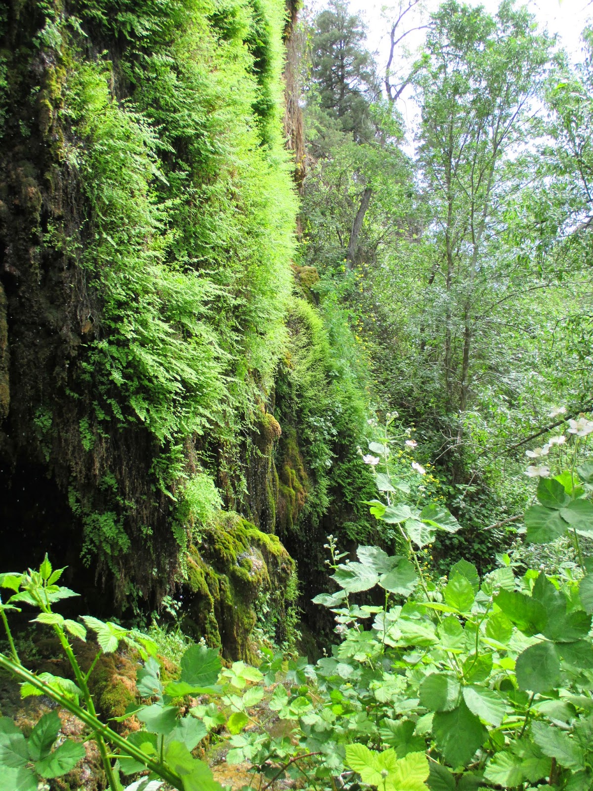
We then did the short "Waterfall Hike".  The Waterfall Hike doesn't really have a waterfall on it.  Instead it's a lush green travertine cliff that's seeping full of water and covered in ferns, mosses, columbines, and other plants.  It's neat, but definitely steep stairways to climb.  There were a lot of wild blackberry plants that made me think that late summer might be a good time to visit here.  We definitely had a good time at Tonto Natural Bridge. 

Nearest City: Payson, AZ
Location: N° W°
Time Needed: 2-3 hours
Difficulty: varies
Kid Friendly: yes
Additional Info: