About Us

Showing posts with label Slot Canyons. Show all posts

Monday, September 21, 2015

Pewits Nest, A Wisconsin Slot Canyon

I'm a fan of slot canyons, wherever they may be, so when I planned our trip to Wisconsin, I put Pewits Nest on the list.  We arrived on a Monday evening and took the last spot in the parking lot.  The parking area is big enough for only about a dozen cars, and judging from how full it was on an off time, and from all of the "No Parking" signs along the road, it's a popular place to visit on evenings and summer weekends.  I'm glad we visited early in the week and avoided the zoo that it must be on weekends.  We parked, then walked not even a quarter mile south to Skillet Creek.  Just before the creek, the trail starts to branch and braid, so we picked one and shortly thereafter were dipping our toes in the water at the end of the gorge.
The slot canyon doesn't get too narrow, but does have several waterfalls in it, with amazing swimming pools throughout.  A few adventurous souls walk out along narrow ledges above one of the pools before cliff jumping into the water below, even though it is prohibited and you could get ticketed for doing so.
We walked played in the pool below last waterfall, then walked along the top of the gorge up to the beginning of the narrows.  We climbed down, then played and splashed in Skillet Creek and walked along the top of some of the waterfalls.  It's a beautiful spot!  We splashed and played and had a great time until we started getting hungry.  We should have brought a picnic with us, but went in to Baraboo for dinner.


Nearest City: Baraboo, WI
Location: From the intersection of U.S. Highway 12 and County W in southwest Baraboo, go west and south on W 1.5 miles to a small parking area south of the road.
Time Needed: varies
Difficulty: easy
Kid Friendly: varies
Additional Info: Pewits Nest Natural Area Website

Tuesday, December 10, 2013

Return to Nature: The Catwalk National Recreation Trail

One of the trip highlights and disappointments from our New Mexico vacation was the Catwalk Recreation Trail.  We stopped by on the first day of the trip, but the Catwalk was closed for repairs, scheduled to open the following day.  We wandered up the trail as far as they let us, to the Catwalk itself, but then had to stop and turn around, tantalized by the view above.  As we drove away, we wondered about what we were missing.  We decided there and then that we'd come back later on if time permitted. 
As fate would have it, we had planned more time at Gila Cliff Dwellings then we really needed, which bumped up the rest of our schedule.  We came back to see what was beyond the next bend.   The Catwalk was built on supports built to support a mine flume which brought water to a mine.  It's wedged in a slot canyon, about 20 feet above Whitewater Creek.  The hike to the Catwalk is easy and accessible for most people.  The part of the hike beyond the Catwalk is in the process of being demolished to restore it to its natural state.  We climbed down to the creek, then made our own trail from that point forward. 
There were several waterfalls, swimming pools, and portions of trail remaining.  All of the bridges had been removed, including a suspension bridge, which left me disappointed.  It had looked pretty amazing in the pictures I had seen! I'm not sure if the area was being "restored" due to environmentalist or environmental impacts and the cost of upkeep.
 Another waterfall with a fantastic swimming pool when the water is warmer.
There were several stretches of a wooded canyon with the creek down it.  Again, very beautiful and peaceful!  I was glad we had come back, and even more glad that we'd come early to have the canyon nearly to ourselves.  When we made it back to the trailhead at lunchtime, it was crowded with several large groups and countless hikers.
We enjoyed the creek toward the top of the canyon, right before where the suspension bridge had been removed.  The missing suspension bridge stopped our progress up the canyon, so we took some time to splash and play as we hiked back downstream.
Since our visit in May 2013, I've heard that the Catwalk has once again been closed due to flashfloods destroying the areas infrastructure. 

Nearest City: Glenwood, New Mexico
Location: 5 miles NE of Glenwood N° W°
Time Needed: 3+ hours
Difficulty: Moderate
Kid Friendly: big kid friendly, with adult help
Additional Info:

Friday, October 4, 2013

Family Backpacking trip to Aravaipa Canyon complete with Bears!

I'm finally getting around to updating a trip to Aravaipa Canyon we had in May.   Late May is a perfect time to visit Aravaipa.  Summer hasn't officially kicked off, so lots of families still have kids in school, but the weather is perfect.  I reserved a few permits to go in the East end, and we made it happen.  We left Sierra Vista after work on Wednesday, and drove to a primitive campsite on Turkey Creek right at the east end of Aravaipa Canyon.  The official trailhead is 1 mile or so east of Turkey Creek, but there are some amazing campsites up the side canyon, and it's a shorter hike, so camping at Turkey Creek before heading out on our backpacking trip made a lot of sense.  I counted 11 stream crossings we had to drive through to get there though.  Most of them are not bad at all if you have a little clearance on your vehicle.  I wouldn't recommend driving a sedan.
We got up on Thursday morning, the first day of our permit, had breakfast, picked up camp, made sure we had everything we'd need in our packs, then headed out!  There's no reason to try and stay dry because the trail for much of the time is in the creek.

The contrast between the streamside riparian area and the desert vegetation higher on the hillsides is really fascinating.  Not many cacti are in the streambed because they will rot if they have too much water. We hiked about 2 miles or so to a great campsite where Deer Creek enters in from the north. 
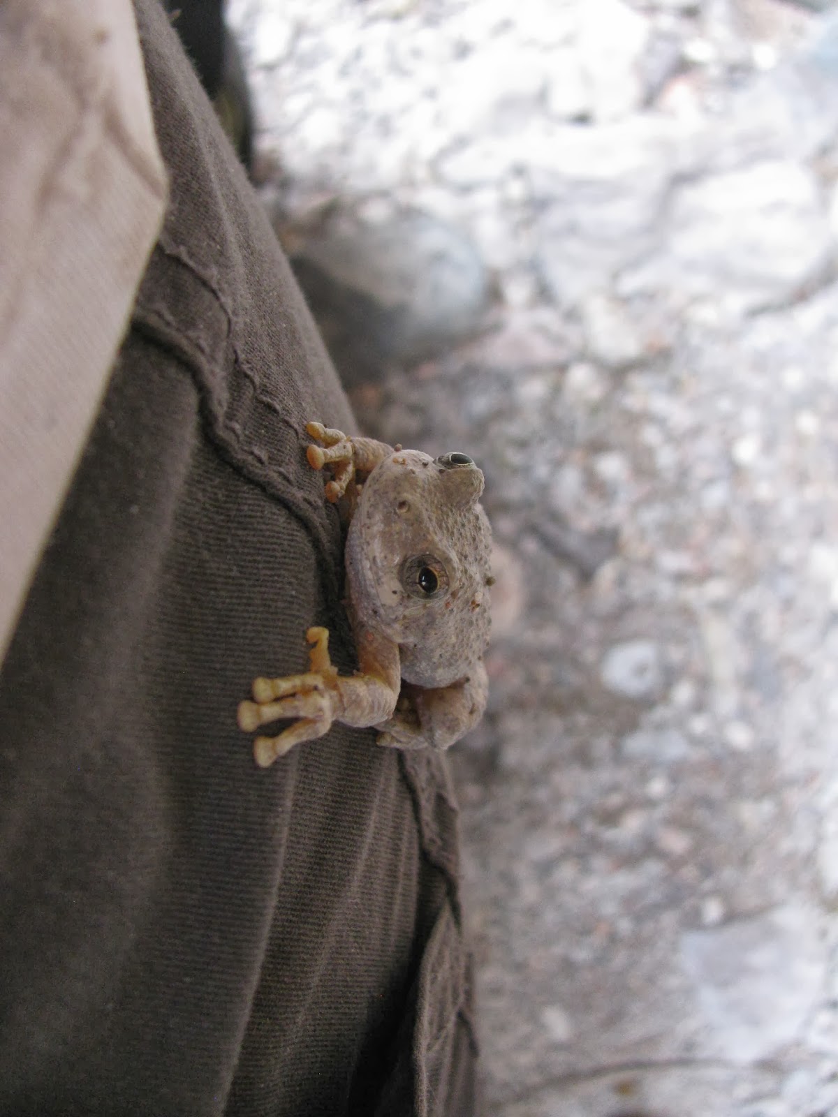
After setting up camp and jettisoning most of our loads, we put on our daypacks with some snacks and water and hiked up Deer Creek to the slot canyon.  Most of Aravaipa can't truly be called a slot canyon, but a ways up Deer Creek definitely fits that definition with the narrow water-sculpted walls.  On the way up, we found a friendly little tree frog that the kids didn't want to leave behind.  We left him and said we'd look on the way back for him. We also saw a few wild blackberry plants that would be fun to forage later in the summer.
The Deer Creek walls got narrower and narrower until finally we could touch both at the same time.  Fantastic!  More!  More! 
But all good things must come to an end, and with kids clamoring for dinner, I turned around to go back to camp and to feed a few hungry little ones.
Here's a picture of the campsite where Deer Creek meets up with the main Aravaipa Canyon.  Fantastic.  Somewhere in here is a lost Gerber pocket knife that slipped out of my pocket.  I had a lot of good adventures with that knife and still miss it
Friday we splashed our way back up the creek on our way out.  We only saw one or two other hikers, a result of the permit system that restricts access to the area.

Back at our Turkey Creek campsite, we went and looked for the Turkey Creek Ruin, constructed by Salado Indians a couple hundred years ago.  We finally found it.  It's not hard to find once you know where to look.  Going up-canyon, you drive through an old corral, after the corral, drive through the streambed and up the small hill on the other side, then park on the right side.  There are a few signs and a short trail to the ruin.  Fantastic!  It's a neat little cliff dwelling. 
Turkey Creek Canyon is an amazing canyon itself.  I really liked the sycamores, walnuts, and other trees.  We camped another night there on Turkey Creek.
Saturday morning, I got up before anyone else and went on a walk.  I walked down the canyon to Aravaipa, then up the road to a stream crossing.  As I turned to retrace my steps, I found that I was cut off from camp by a momma bear and two babies right where Aravaipa Creek and Turkey Creek come together!  I watched them for a while, then ran to get the camera.  They were pretty skittish and the cubs ran up a tree as soon as I let them know I was there.  Momma soon joined them.  It was the perfect way to cap of an unforgettable backpacking trip.


Nearest City: Klondyke, AZ
Location: N° W°
Time Needed: At least 2 days
Difficulty: Easy as far as backpacking goes
Kid Friendly:
Additional Info:

Tuesday, September 25, 2012

Fun at Maple Canyon

Maple Canyon is another place that's been on my radar for a while.  We got out there this past weekend and had a blast.  I sometimes wonder why it takes me so long to go to some of these places!  Maple Canyon is no exception- especially since I went to school at Snow College for a semester or two.  I'm almost ashamed to admit that I never made it to Maple Canyon when I was at Snow.  What's the draw?  Rock climbing, hiking, an arch, a cave, and the closest slot canyon to Salt Lake City.  If you're into camping, there's both a pay campground ($8/night) or primitive (free) camping.  Finally, if you visit in the fall, the leaves are changing colors and it makes a fantastic place even more beautiful. 
After spending the night at a primitive campsite, we woke up with the sun and after a delicious breakfast, headed out to find the Box Canyon.   The Box Canyon of Maple Canyon is a small slot canyon located about halfway between the mouth of the canyon and the campground on the north side of the canyon.  It's unmarked, but not hard to find. 
The unique thing is that it's a slot canyon in conglomerate instead of sandstone or limestone.  It's a very unique experience.  There's a few handlines and other scrambles to get up, but it's generally not very difficult.  Most of the canyon is about 20 feet wide, but it gets down to about 6 feet wide in the upper end. 
All told, it's not more than a half mile long, so it's pretty short as far as slot canyons go, but at the same time a slot is a slot and it's hard to go wrong with slot canyons. 
We climbed up to this small waterfall then turned around.  There is a rope on the right side for the more adventurous, but since we couldn't get the kids up, I climbed part way up before climbing back down. 

We then went hiking up the Middle Fork Trail to find the arch.  The leaves were really colorful along the trail.  It's about a 3/4 mile hike from the trailhead to the arch, the last 150 feet being very steep. 
The arch was pretty cool, with the large rocks and boulders of the conglomerate cemented together a pretty amazing site.  It's easier for me to visualize a sandstone arch, but the conglomerate arch seemed so fragile and apt to tumble even though the rock is very solid. 
 After seeing the arch, we wandered back down for lunch and to let the kids run around for a while. 
After lunch and the break, we took another hike, this one up the Right Fork Trail.   We went to the Pipedream Climbing area to take a look at the cave. 
 The cave is actually a grotto because it isn't deep enough to get completely dark, but it's pretty neat to see.  There's a 15 foot climb at the entrance to get inside. 
Outside, we watched several climbers climbing on the cliffs.  After finishing a route, this climber had a free-hanging belay down to the ground. 
More fall leaves.  It was a great time to visit Maple Canyon!

*We also saw several wild raspberry plants and thimbleberry plants while we were hiking.  Earlier in the year would be a good time to visit if you're interested in picking wild berries.

Nearest City: Freedom, UT
Location: N° W°
Time Needed: Lots!
Difficulty: Varies
Kid Friendly: Yes
Additional Info:  There is a $3 day use fee.

Friday, June 22, 2012

Oneonta Gorge: The Zion Narrows of the Pacific Northwest

I'm a big fan of slot canyons.  As I was researching for the trip, I stumbled on a picture of Oneonta Gorge.  It immediately went on the "MUST DO" list for while we were in Oregon.  Slot canyons are awe inspiring. Most of them are in Southern Utah in a dry desert region known as the Colorado Plateau.   A slot canyon in Oregon and green with vegetation- I've gotta see this!
Oneonta Gorge is a small side canyon to the Columbia River Gorge.  It's only about 1/3 of a mile long, but the narrow walls, green with ferns and mosses is astonishingly beautiful.  It's about 2 miles east of the wildly popular Multnomah Falls, but only sees a small fraction of the visitors.  I didn't mind.  The canyon changes with every flood, so you can expect water from ankle deep, up to pools deep enough to swim in.  The waterfall at the end is a popular swimming hole during warmer weather. 
Near the entrance of the gorge, several signs alert you that climbing on the log jam can be hazardous.  If you go, be sure to exercise caution if you climb on the logjam!  It's not my fault if you get hurt. 
A closer picture of the logjam.  There are several trees 3-4 feet in diameter among the branches and debries.  I climbed up on a big boulder on the east side before continuing over the logs.
 You can see the boulder and logs in this picture.  Even from here, the canyon looks amazing, 
On the other side of the logjam, the canyon beacons you in.  I wasn't equipped for swimming or much wading, so this is as far as I got.  I couldn't help but think it looked similar to the Narrows of the Virgin River in Zion National Park.  But green.  And smaller.  But an amazing place just the same.
Nearest City: Cascade Locks, OR
Location: 2-3 miles east of Multnomah Falls
Time Needed: Varies
Difficulty: Varies
Kid Friendly: Not really
Additional Info:

Wednesday, November 30, 2011

Cathedral Gorge State Park

After the brief detour to Mountain Meadows, we got back on the road en route to our real destination- Cathedral Gorge. 
Cathedral Gorge is basically the sediment deposit of an old lake that is slowly eroding.  The walls of the canyon have all sorts of pretty neat forms and spires.  There are also countless small "slot canyons" that wind back into the canyon wall.  Although they're not very long, the close walls and sculpted heights are amazing.  We spend several hours wandering into and out of the small canyons and playing on the rock mounds.  It's definitely a kid's paradise. 
The lighting in some of the canyons was difficult, but some of the pictures turned out alright. 
We had intended to do a loop and visit here, the Lost City Museum, and Valley of Fire State Park, but it ended up being such a cool area we decided to truncate the loop and spend most of a day in the Panaca/Caliente area.  We still weren't able to see/do everything and I'm thinking that it would be a great little spot to come back to and spend a few days playing in the dirt, soaking in some hot springs, digging trilobites, visiting ghost towns, and finding petroglyphs. 

Nearest City: Panaca, NV
Location: N° W°
Time Needed: Cathedral Gorge is about 2 hours from St. George, 1.5 hours from Cedar City, or 2 hours from Vegas.  You could spend several hours at the State Park, and find plenty of other things to do nearby to fill up several days.
Difficulty: Easy
Kid Friendly: Yes
Additional Info:  Lincoln County Nevada Tourism

Wednesday, August 3, 2011

Little Wildhorse Canyon

After the great Burr Trail Fiasco, we had to decide if we should head home the most direct route possible, or if it was ok to play a little bit more.   After looking at the maps, we decided that the most direct route home was only about 40 miles less than the the route we wanted to take.  Hmm...cut the trip short, or play another half-day...cut the trip short, or play another half day...cut the trip--NAH!  It just wouldn't be right to do something like that!  So after a great night's sleep, we picked up camp and set off toward Goblin Valley. 
We decided to stop at Little Wildhorse Canyon to give the kids a taste of another slot canyon. Actually, Little Wildhorse is the introductory slot canyon for a lot of people.  With easy access, sculpted narrows, easily surmounted challenges, and a short entry hike, it's easy to see why it's such a popular slot.   Some people turn it into a loop hike in conjunction with Bell's Canyon, but after doing it once about 5 years ago I quickly decided it's not worth doing again.  Bells Canyon never really slots up, and the hike across the top of the triangle isn't very fun.  Why do LWH just one way, when doing it in reverse adds to the fun?
The kids really enjoyed the canyon- especially the first set of narrows.  The second set of narrows was full of water.  I bridged over the top and went a short way further up the canyon then turned around to tell everyone else that the water section was short.  Ultimately we decided not to go further.  There were just too many kids who were close to naptime that going further would have been more effort than it was worth. 
The way back down the canyon was still fun.  We paused again in the narrows for some more stemming practice.  It was pretty sweet because even the youngest one was able to do some stemming.  The kids thought they were pretty hot stuff.  I always enjoy watching kids having fun.  Even though we didn't do it all, this is a great little canyon.
Nearest City: Hanksville or Green River, UT
Location: N° W°
Time Needed: 1-3 hours
Difficulty: Easy-Moderate
Kid Friendly: Yes- most of the time
Additional Info:  Most of the time, the biggest obstacle is the crowds of other people.  Most of the queuing will generally occur at the narrow places in the canyon.  Go early or late to have the canyon to yourself.  You also could find water in the slot and some short up/downclimbs among other things.  As with all desert hikes- bring enough water.